Severe Storms and Arctic Cold Front to Impact Greater Houston Area
Residents of the Greater Houston area should prepare for severe storms this weekend, followed by an Arctic cold front next week that could bring dangerously cold temperatures and hard freeze conditions. According to the National Weather Service (NWS), strong to severe storms are expected Saturday afternoon through the evening, and an Arctic front will arrive Tuesday night, bringing bitterly cold temperatures through the middle of next week.
Severe Weather Threat on Saturday
A cold front moving through Texas on Saturday, February 17 will trigger showers and thunderstorms across Southeast Texas, some of which could become severe. Areas near Crockett, Livingston, and Huntsville are under a Slight Risk (Level 2 of 5) for severe weather, while College Station, Houston, and Galveston fall under a Marginal Risk (Level 1 of 5).
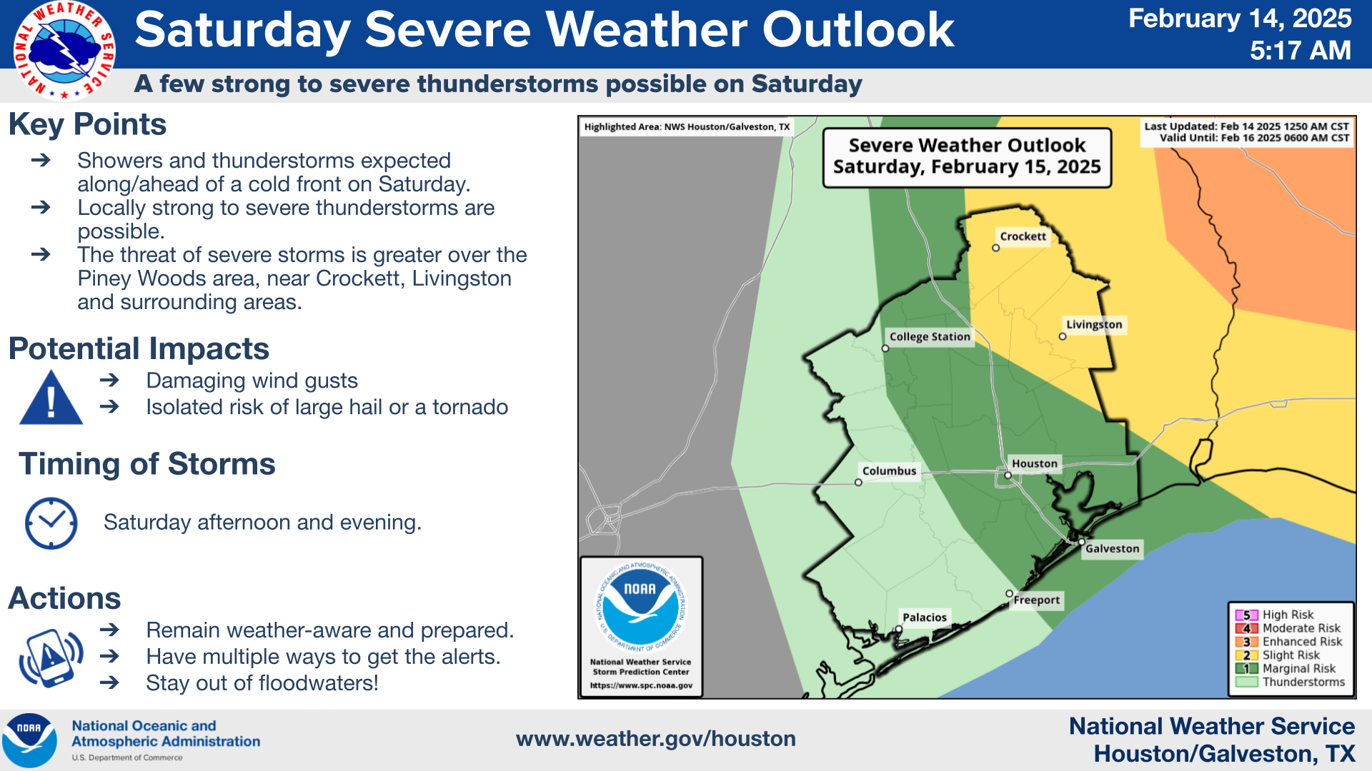
The primary hazards associated with these storms include:
- Damaging wind gusts
- Isolated tornadoes
- Large hail
Storms are expected to develop Saturday afternoon and last through early evening, with the severe weather threat diminishing once the cold front pushes through after sunset.
How to Prepare for Strong Winds
- Secure outdoor furniture – Patio chairs, tables, and umbrellas can become dangerous projectiles in high winds. Store them in a garage or anchor them down.
- Bring in small potted plants – Wind gusts can easily knock over lightweight planters. Move them indoors or to a sheltered area.
- Check fences and outdoor decorations – Loose fence panels, holiday decorations, and garden décor should be secured or stored.
- Charge devices and have flashlights ready – Strong winds may lead to isolated power outages. Keep phones and portable chargers fully charged.

Arctic Cold Front to Bring Hard Freeze Conditions
Following the weekend storms, an Arctic cold front will sweep through Southeast Texas on Tuesday night, bringing some of the coldest temperatures of the season. Wind chills could drop to 15°F or lower in parts of the region by Wednesday night.
What to Expect with the Arctic Cold Front
- Frigid temperatures – Hard freeze conditions are possible, especially in northern counties.
- Dangerously low wind chills – Breezy conditions will make temperatures feel even colder.
- Little to no winter precipitation expected – Although confidence is low for snow or ice, very cold temperatures are expected across the area.
How to Prepare: The Four P’s of Cold Weather Safety
Residents should take precautions to protect people, pets, plants, and pipes ahead of the freeze.
- People – Dress in warm layers, limit time outdoors, and check on elderly neighbors who may need assistance staying warm.
- Pets – Bring pets inside or provide a warm, insulated shelter with access to unfrozen water.
- Plants – Cover sensitive plants with blankets or sheets, or bring potted plants indoors.
- Pipes – Wrap exposed pipes and let indoor faucets drip to prevent freezing.

Stay Informed and Be Prepared
The forecast may change over the next few days, so residents are encouraged to monitor local weather updates. The National Weather Service, local news stations, and emergency management agencies will provide updates as the storm system and Arctic cold front approach.
By taking precautions now, Houston-area residents can protect their homes, families, and pets from severe weather and freezing temperatures in the days ahead.
 Tiffany Krenek has been on the My Neighborhood News team since August 2021. She is passionate about curating and sharing content that enriches the lives of our readers in a personal, meaningful way. A loving mother and wife, Tiffany and her family live in the West Houston/Cypress region.