Spring ISD Closes Schools January 21-22 Due to Severe Winter Storm Forecast
Spring Independent School District (Spring ISD) announced the closure of all schools and offices on Tuesday, January 21, and Wednesday, January 22, due to the forecast of hazardous winter weather conditions. The district is urging families and staff to prioritize safety and stay informed through official communication channels for further updates.
National Weather Service Winter Storm Warning
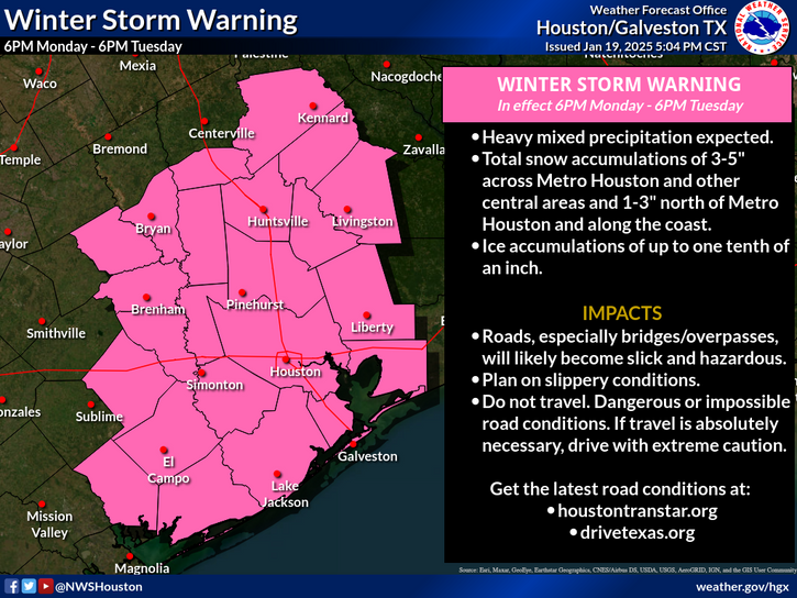
The decision to close schools follows an alert from the National Weather Service Houston/Galveston issued at 2:30 PM on Sunday, January 19, 2025. According to the NWS, a potentially historic winter storm is set to impact southeast Texas starting Monday night and continuing through Tuesday. The storm is expected to bring significant snow, ice, and dangerously low temperatures, creating hazardous or even impossible driving conditions across the Greater Houston area, potentially lasting for multiple days.
 (Source: NWS-Houston/Galveston)
Key details from the National Weather Service include:
-
Winter Storm Warning: In effect from 6:00 PM Monday to 6:00 PM Tuesday.
-
Snowfall Projections:
-
Northern areas: 2 to 4 inches
-
Central and eastern areas: 3 to 5 inches
-
Southern areas: 1 to 3 inches, with locally higher amounts possible.
-
-
Ice Accumulation: Up to one-tenth of an inch in southern and coastal areas.
-
Cold Temperatures: A hard freeze is expected for all inland areas Tuesday night into Wednesday morning, with minimum temperatures below freezing across the region through Thursday morning.
“A potentially historic winter storm will impact southeast Texas beginning on Monday night and continuing on Tuesday, producing widespread snow and ice and dangerous or impossible driving conditions around Houston—perhaps for multiple days,” the NWS stated.
Mobile Sidebar Ad
Impact on Spring ISD Operations
All before- and after-school activities, as well as events scheduled for January 21-22, have been canceled. Spring ISD encourages families and staff to take necessary precautions and to monitor local news outlets and district platforms for updates regarding the weather and potential additional schedule changes.
Preparing for Severe Weather
With the storm expected to bring widespread snow, sleet, and ice, area residents are advised to prepare for potentially dangerous conditions. Key recommendations include:
-
Avoiding Travel: Roads may become treacherous due to snow and ice accumulation, so unnecessary travel should be avoided.
-
Protecting Homes: Insulate exposed pipes and cover outdoor faucets to prevent freezing.
-
Caring for Pets and Plants: Bring pets indoors and ensure plants are adequately protected from freezing temperatures.
The heaviest precipitation is forecasted for Tuesday morning through early afternoon, with localized heavier bands of snow and sleet expected during this time. A hard freeze Tuesday night into Wednesday morning will likely exacerbate the situation, causing lingering travel disruptions.
 Tiffany Krenek has been on the My Neighborhood News team since August 2021. She is passionate about curating and sharing content that enriches the lives of our readers in a personal, meaningful way. A loving mother and wife, Tiffany and her family live in the West Houston/Cypress region.