
FEMA Releases Draft Floodplain Maps for Harris County Through MAAPNext Initiative
Editor's Note: Updated 2/12/2026 at 9:29 PM
Flood risk mapping in Harris County is undergoing an important update — but residents should know that nothing changes right now when it comes to flood insurance requirements or development regulations.
Last week, the Federal Emergency Management Agency (FEMA) released draft floodplain mapping information to the 34 floodplain administrators in Harris County as part of the MAAPNext effort. MAAPNext is a FEMA-led initiative supported by the Harris County Flood Control District (HCFCD), which is providing local expertise throughout the process.
The Harris County Flood Control District plans, implements, and maintains flood risk reduction projects guided by community and natural values. The district manages more than 1,500 bayous and creeks totaling approximately 2,500 miles in length. Its mission includes devising flood damage reduction plans, implementing those plans, and maintaining flood control infrastructure across the county.
The draft maps reflect changing conditions in Harris County, including a more than 30% increase in rainfall rates, updated topographic data, and advanced modeling.
Why FEMA Is Updating Harris County Flood Maps
After major storms between 2015 and 2017 — including Hurricane Harvey — it became clear that existing floodplain maps were not fully reflecting flood risk. Thousands of families flooded outside of mapped high-risk areas, a reality that reshaped how local and federal officials approach flood modeling.
Updated maps are intended to help residents, businesses, emergency managers, and local governments better understand flood risk and make more informed decisions.
While map updates can sometimes raise concern, officials emphasize that improved modeling provides a clearer picture of risk across the county.
Important: These Are Draft Maps Only
At this stage, FEMA’s release is strictly for technical review by local floodplain administrators.
The maps are:
- Draft versions
- Not final
- Not regulatory
- Not part of FEMA’s formal public appeal and comment process
As a result:
- Flood insurance requirements do not change right now
- Development regulations do not change right now
Any formal adoption process, including public notification and appeals, would occur later.
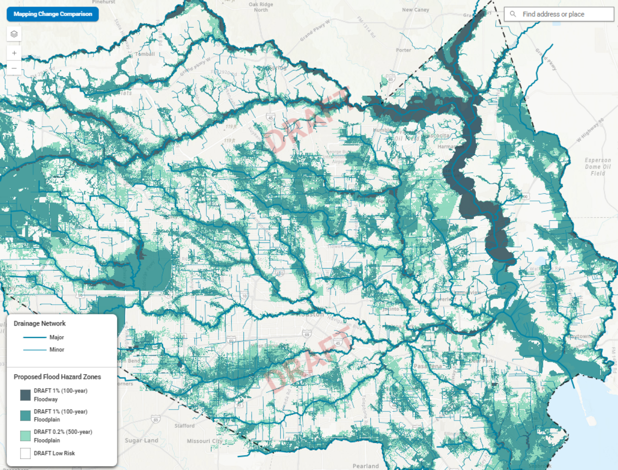 Click to enlarge. (Source: HCFCD)
Making FEMA’s Information Easier to Understand
Recognizing that floodplain mapping can be complex and difficult to navigate, the Harris County Flood Control District originally announced it will launch a public-friendly online map viewer next week. On Thursday, February 12, officials announced that the viewer is now available at hcfcd.org/MAAPnext. The viewer displays the same draft FEMA data in a clearer, easier-to-understand format.
“This tool is about transparency and public understanding,” said Dr. Tina Petersen, executive director of the Flood Control District. “Flood risk is personal for so many families in Harris County, and our goal is to make this information easier to access and easier to understand.”
In addition, HCFCD will host informational webinars and continue working closely with floodplain administrators, local partners, and community stakeholders to help residents understand what the draft maps mean and what comes next.
Reflecting Progress in Flood Mitigation
The draft FEMA maps also incorporate flood mitigation projects completed or under construction through 2020. According to the Flood Control District, early results show areas where flood risk has decreased because of those investments, including projects made possible through the 2018 Bond Program.
That means in some neighborhoods, families who once faced repeated flooding are now seeing measurable reductions in mapped risk.
Officials note there is still more work to do. Hundreds of millions of dollars in additional construction is set to begin this year as Harris County continues investing in flood risk reduction infrastructure.
As the MAAPNext process continues, HCFCD says it is committed to being a trusted resource and a conduit for the community, ensuring residents have the opportunity to understand, respond to, and participate in the mapping process.
More information, including frequently asked questions, is available at hcfcd.org.
Residents are encouraged to stay informed as the technical review progresses and to follow My Neighborhood News for updates as FEMA’s draft floodplain maps move through the next stages.
 Tiffany Krenek has been on the My Neighborhood News team since August 2021. She is passionate about curating and sharing content that enriches the lives of our readers in a personal, meaningful way. A loving mother and wife, Tiffany and her family live in the West Houston/Cypress region.