Fort Bend Water Rules, Subsidence Data Signal What’s Changing for Homeowners, Flood Risk, and Future Growth
The ground beneath parts of Fort Bend County is still slowly sinking—and new data shows that what happens next will depend heavily on how the region uses water.
At a recent public hearing, the Fort Bend Subsidence District (FBSD) released updated findings from its 2025 Annual Groundwater Report, offering one of the clearest looks yet at how groundwater use, population growth, and policy changes are shaping flood risk, infrastructure stability, and long-term water costs across communities like Katy, Fulshear, Sugar Land, and Rosenberg.
For residents, this isn’t just a technical issue. It directly connects to home foundations, drainage performance, road conditions, and utility bills—making it one of the most important long-term infrastructure stories in Fort Bend County.
What the New Data Shows About Sinking Land in Fort Bend
Subsidence—when land gradually sinks due to underground changes—continues to be measured across the region using advanced monitoring systems.
According to the report:
- In the Katy/Fulshear area, ground levels have dropped about 15.3 centimeters since 2021, averaging 3.32 cm per year
- In Sugar Land, long-term subsidence totals about 33.1 centimeters since 1994, with slower recent rates
- In Rosenberg, subsidence has been more limited, with about 9.9 centimeters since 1999
While gradual, these shifts can affect how water drains across neighborhoods, potentially increasing localized flood risk and placing stress on infrastructure over time.
The Root Issue: Groundwater Use and Aquifer Pressure
The primary driver behind subsidence is groundwater overuse.
When water is pumped from underground aquifers faster than it can be replenished, the soil layers compress—causing the surface above to sink. In Fort Bend County, groundwater still plays a major role in meeting demand.
In 2025 alone:
- The district used approximately 88.5 million gallons per day (MGD) of groundwater
- Total water demand reached about 212.1 MGD, showing how rapidly usage is growing
At the same time, groundwater levels in many areas are declining, with widespread drops observed between 2021 and 2026—especially in northern parts of the county.
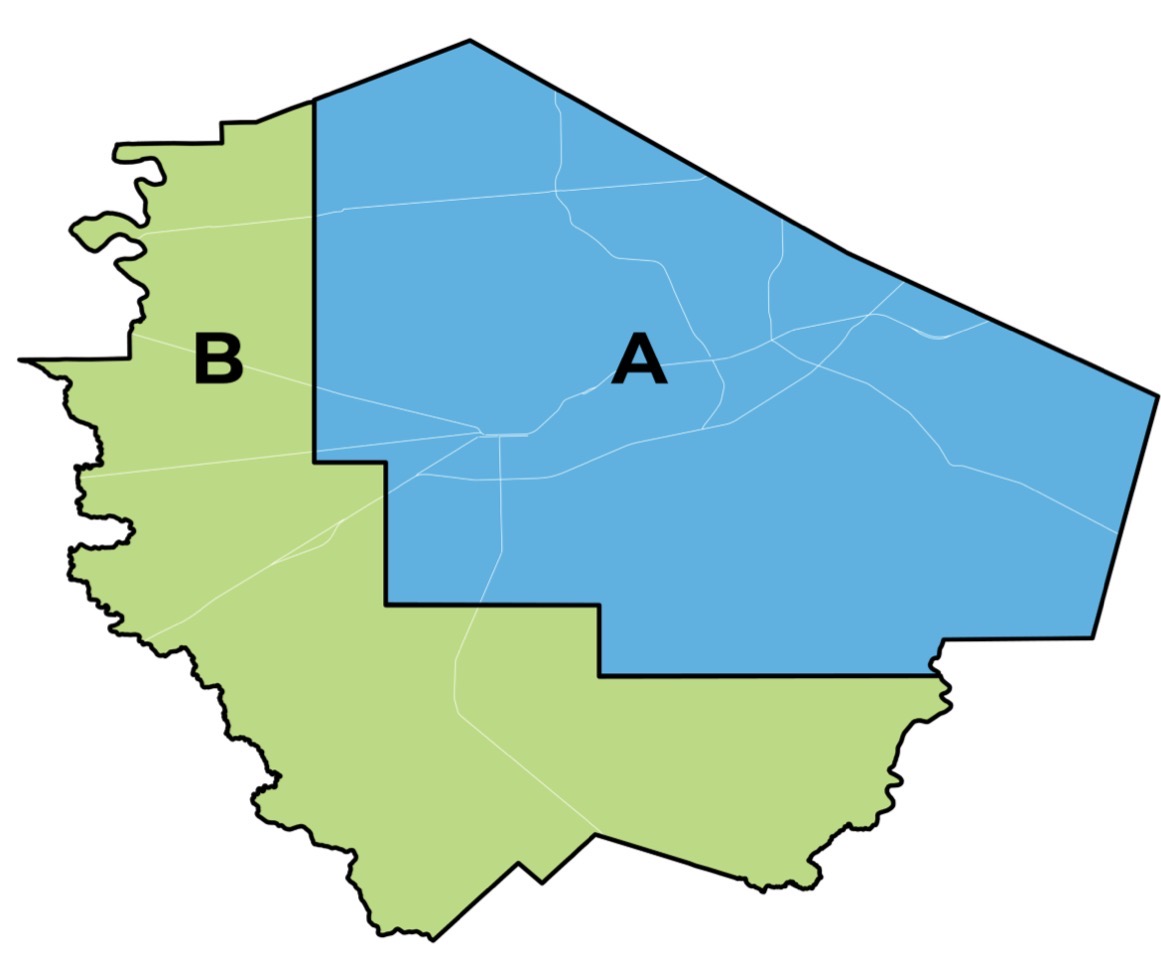
Understanding FBSD Regulatory Areas: What Changes by 2030 and 2035
One of the most important takeaways from the report—and one that directly affects residents—is how the county is divided into Regulatory Area A and Area B, each with its own timeline for reducing groundwater reliance.
According to the FBSD Regulatory Areas map:
-
Area A (primarily eastern and more developed portions of Fort Bend County): Must limit groundwater to no more than 40% of total water demand by 2030
- Area B (generally western and more rural/developing areas): Must meet that same 40% limit by 2035
 (Source: FBSD)
This phased approach reflects differences in development and infrastructure readiness—but it also means some neighborhoods will see water system changes sooner than others.
What This Means for Your Water Bill and Infrastructure
As communities shift away from groundwater and toward surface water sources like the Brazos River, residents may notice changes over time.
The report shows that alternative water use has already grown to about 123.5 MGD, with most coming from the Brazos River.
While surface water helps reduce subsidence, it is:
- More expensive to treat and transport
- Dependent on large-scale infrastructure systems
That means:
- Water rates may increase gradually
- Infrastructure investments will expand
- Long-term benefits include reduced flood risk and better protection of roads and homes
Where the Water Is Going: Residential Use Plays a Major Role
Breaking down groundwater use helps clarify the bigger picture.
In Regulatory Area A, the majority of groundwater—about 89%—is used for public supply, meaning residential and municipal use
In Area B, usage is more mixed, with a significant portion tied to agriculture
This highlights an important point: What happens at home—especially outdoor watering—has a measurable impact on regional water demand.
Why Conservation Still Matters in a Flood-Prone Region
It can feel counterintuitive to talk about conserving water in an area known for heavy rains. But flooding and water supply are two very different challenges.
- Floodwater often runs off quickly and doesn’t recharge aquifers
- Population growth increases daily demand year-round
- Groundwater recharge is slow and unpredictable
That’s why conservation remains one of the most effective tools available.
Even small changes—like adjusting sprinkler schedules, fixing leaks, or using drought-tolerant landscaping—can reduce pressure on aquifers when scaled across thousands of homes.
How the Data Is Measured: High-Tech Monitoring Behind the Scenes
To track subsidence accurately, FBSD relies on advanced technology, including:
- A network of GPS stations transitioning to continuous daily monitoring through 2027
- Satellite-based InSAR technology, capable of detecting land movement down to millimeters
This level of precision allows officials to identify trends early and adjust water policies accordingly.
What Happens Next for Fort Bend County
The 2025 Annual Groundwater Report will be presented to the FBSD Board of Directors for approval, with public input accepted through early May.
Looking ahead, the path forward will likely include:
- Continued expansion of surface water systems
- Ongoing groundwater regulation
- Increased emphasis on conservation
- Planning for population-driven demand
For residents, the biggest takeaway is this: Water use, infrastructure, and land stability are all connected—and the decisions made today will shape how Fort Bend communities grow and manage flood risk for decades to come.
Residents can explore tools, tips, and educational resources through Smarter About Water, a regional initiative focused on helping households play a role in water conservation and long-term sustainability.
Stay tuned to My Neighborhood News for continued coverage of Fort Bend County infrastructure, water policy, and what it means for your neighborhood.
 Tiffany Krenek has been on the My Neighborhood News team since August 2021. She is passionate about curating and sharing content that enriches the lives of our readers in a personal, meaningful way. A loving mother and wife, Tiffany and her family live in the West Houston/Cypress region.