Weather
Severe Weather Warning Issued by Harris County Office of Emergency Management
Tomball / Magnolia / Tomball / Magnolia
November 30 2023
The Harris County Office of Homeland Security & Emergency Management (HCOHSEM) is monitoring a strong storm system that is moving through our area this morning and will continue into the evening.
BE WEATHER AWARE TODAY! Heavy rainfall is likely across most of our area. Residents can expect 1-3 inches of rain with isolated areas seeing up to 5 inches. Damaging wind gusts and large hail are also possible but the main threat is a chance of isolated tornadoes. Severe weather chances are highest beginning in the late morning and into the early evening hours.
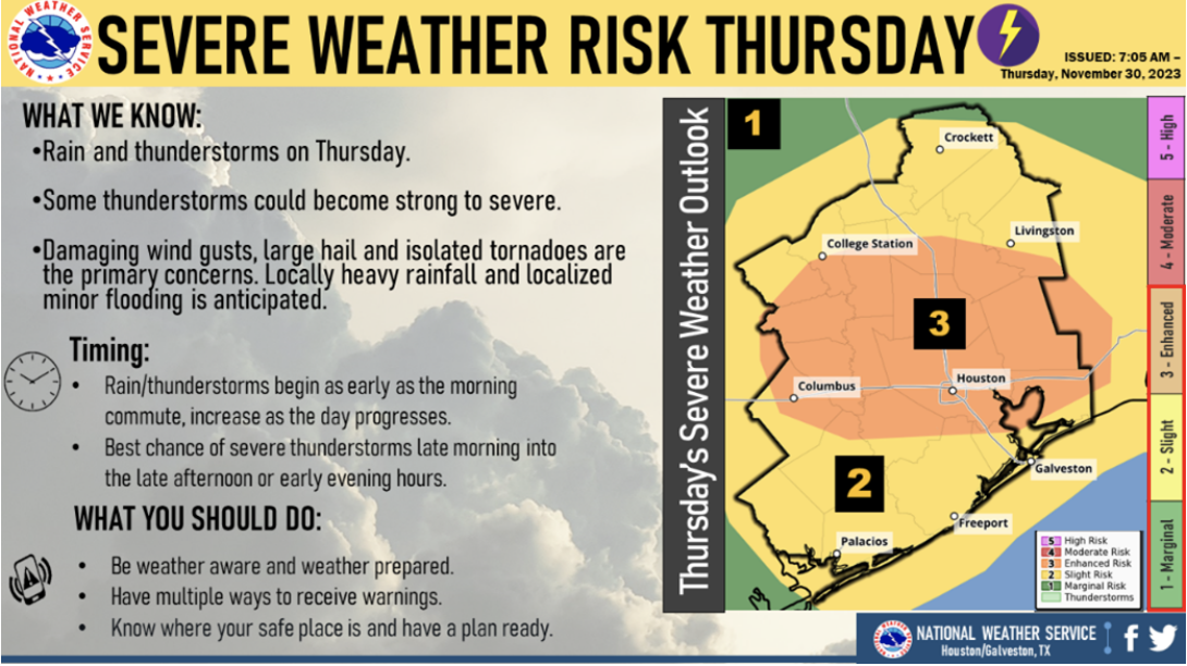
- Monitor media sources for severe weather information. Follow weather safety advice from the National Weather Service (NWS) and other official sources.
- If a Tornado Warning is issued, go into an interior room on the lowest floor of the building you are in and stay away from windows. Remain there until the danger has passed. For more information on tornado safety, visit www.ready.gov/tornadoes.
- Street flooding is possible in areas where the heaviest rain falls today. Before getting on the road, check the Houston TranStar live traffic map for information on road conditions.
- Short periods of intense rainfall can cause temporary rises along our network of streams and bayous. You can see real time information on waterway conditions using the Harris County Flood Control District Flood Warning System.
- Today is a good day to make sure that your mobile devices are set to receive wireless emergency alerts (WEA). NWS will use these alerts to warn residents in the path of potentially dangerous weather. WEA messages save lives. Apple | Android
HCOHSEM will provide updates via social media, ReadyHarris Alerts and ReadyHarris Accessible Alerts.
Source: ReadyHarris
