FEMA’s Proposed Flood Map Could Reshape Risk Across Harris County, With Major Impacts in Cypress and Beyond
For many Harris County residents, flood maps are more than lines on a page. They can influence insurance costs, home values, development standards, infrastructure planning, and how communities prepare for future storms.
Now, a proposed update from the Federal Emergency Management Agency (FEMA) could bring significant changes to how flood risk is defined across the region.
According to a new analysis by Rice University’s Kinder Institute for Urban Research, FEMA’s proposed flood map would add nearly 200 square miles of land to Harris County floodplains and result in a net increase of approximately 115,000 housing units located within flood-prone areas. While the map remains years away from final approval, the proposal offers an early look at how flood risk designations could shift across one of the nation’s fastest-growing metropolitan areas.
Why the Proposed FEMA Flood Map Matters
FEMA has not comprehensively updated Harris County’s flood maps since 2007. Since then, the region has experienced multiple major flood events, including Hurricane Harvey, while also seeing substantial residential and commercial development.
The proposed update reflects new data and modeling intended to better identify areas vulnerable to flooding.
According to the Kinder Institute analysis, approximately 175,000 housing units that are currently outside FEMA-designated floodplains would move into a floodplain under the proposed map. At the same time, about 60,000 housing units would be removed from floodplain designations.
The changes could have important implications for homeowners, renters, businesses, local governments, and school districts throughout Harris County.
Property owners newly placed within a floodway or 100-year floodplain would likely experience the most significant impacts, potentially including flood insurance requirements for federally backed mortgages and additional development regulations. Those added to the 500-year floodplain would generally face fewer regulatory impacts but could still see changes in risk assessments and planning considerations.
Harris County Floodplains Would Expand Significantly
The Kinder Institute’s analysis shows that under the current FEMA map, nearly 640 square miles of Harris County’s 1,777 square miles are located within a floodplain.
Under the proposed map:
- About 571 square miles would remain within floodplains.
- Approximately 265 square miles would be newly added.
- About 66 square miles would be removed.
As a result:
- The 100-year floodplain would increase from 301 square miles to 445 square miles.
- The 500-year floodplain would grow from 210 square miles to 268 square miles.
- The floodway would slightly decrease from 126 square miles to 124 square miles.
Many of the newly added areas are located near major waterways but farther from bayous, rivers, reservoirs, and creeks than properties currently designated within floodplains.
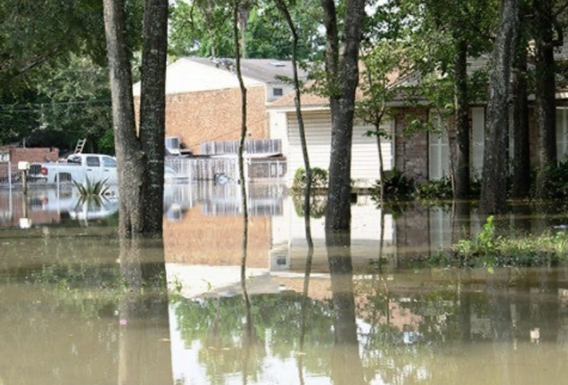
Cypress Among the Areas Facing the Largest Changes
Some of the most significant impacts would occur in northwest Harris County.
The Kinder Institute found that four Cypress-area neighborhoods alone would experience a net increase of approximately 24,500 single-family homes and 6,100 multifamily units added to floodplain designations.
The area’s network of creeks and tributaries, along with White Oak Bayou, contributes to flood risk throughout portions of the rapidly growing community.
A cluster of five neighborhoods in northeast Harris County would also see major changes, with a combined 18,500 housing units moving into floodplains. Many of these communities experienced severe flooding during Hurricane Harvey from creeks, bayous, and the San Jacinto River watershed.
Other areas expected to see notable increases include:
- Aldine
- Pasadena
- Far western Harris County
Meanwhile, some communities could see fewer properties classified within floodplains. The South Belt/Ellington area would experience the largest reduction, with approximately 13,000 housing units removed from floodplain designations. In Alief, nearly 9,300 residential units would no longer be mapped within a floodplain under the proposal.
Schools, Public Facilities, and Infrastructure Also Affected
The proposed FEMA map would extend beyond residential properties.
According to the Kinder Institute analysis, approximately 110 public school campuses would be newly designated within floodplains. The largest concentrations would occur within:
- Houston ISD
- Cypress-Fairbanks ISD
- Aldine ISD
- Pasadena ISD
- Spring ISD
At the same time, nearly 100 campuses would be removed from floodplain designations, primarily within Alief ISD, Houston ISD, and Pasadena ISD.
The proposal would also affect critical public infrastructure.
Approximately 40 municipal wastewater treatment plants would be newly mapped within floodplains, with nearly half located in the Cypress area. Only three wastewater facilities would be removed from floodplain designations.
The issue carries added significance because wastewater treatment facilities play a critical role during disasters. During Hurricane Harvey, treatment plant failures resulted in tens of millions of gallons of raw sewage and industrial discharges entering surrounding waterways and communities.
Emergency response infrastructure would also see changes:
- About 15 fire and EMS stations would be newly added to floodplains.
- Approximately 20 fire and EMS facilities would be removed.
- Two police stations would be added.
- Three police facilities would be removed.
Because many of these facilities serve as emergency response centers and community gathering points during disasters, floodplain designations can influence future planning, construction, insurance, and mitigation investments.
What Happens Next?
Residents should not expect immediate changes.
The proposed map remains subject to extensive local, state, and federal review processes before receiving final approval. According to the Kinder Institute’s analysis, FEMA is still at least two years away from completing the process.
During that time, local governments, engineering experts, property owners, and community stakeholders will have opportunities to review and comment on the proposed revisions.
Still, the proposal offers an important preview of how flood risk may be reevaluated across Harris County in the coming years.
For homeowners, prospective buyers, renters, and community leaders, understanding these potential changes now may help inform future decisions about insurance coverage, property investments, infrastructure improvements, and long-term resilience planning.
The analysis was conducted by the Rice University Kinder Institute for Urban Research, which examined FEMA’s proposed floodplain updates and mapped their potential impacts on neighborhoods, housing units, schools, government facilities, and critical infrastructure throughout Harris County.
As the review process moves forward, residents across the region—particularly in Cypress, northeast Harris County, Aldine, Pasadena, and other high-growth areas—will be watching closely to see how the final flood maps ultimately take shape.
 Tiffany Krenek has been on the My Neighborhood News team since August 2021. She is passionate about curating and sharing content that enriches the lives of our readers in a personal, meaningful way. A loving mother and wife, Tiffany and her family live in the West Houston/Cypress region.