








Tropical Storm Bertha Poses Low Risk to Southeast Texas, but Dangerous Heat Takes Center Stage
For Southeast Texas families watching the Gulf, the latest forecast offers a measure of reassurance: Tropical Storm Bertha is not expected to bring significant impacts to the Houston-Galveston region.
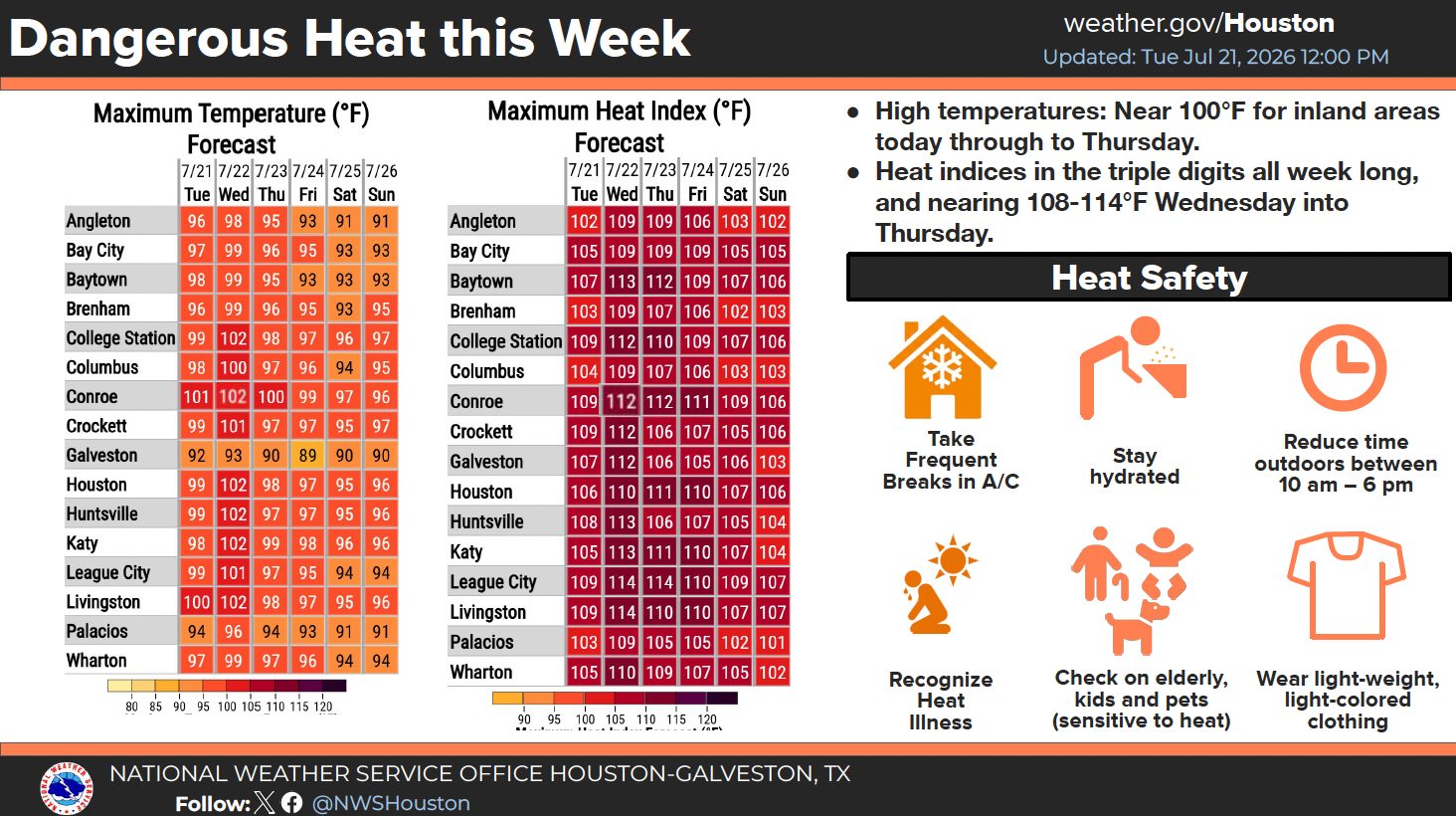
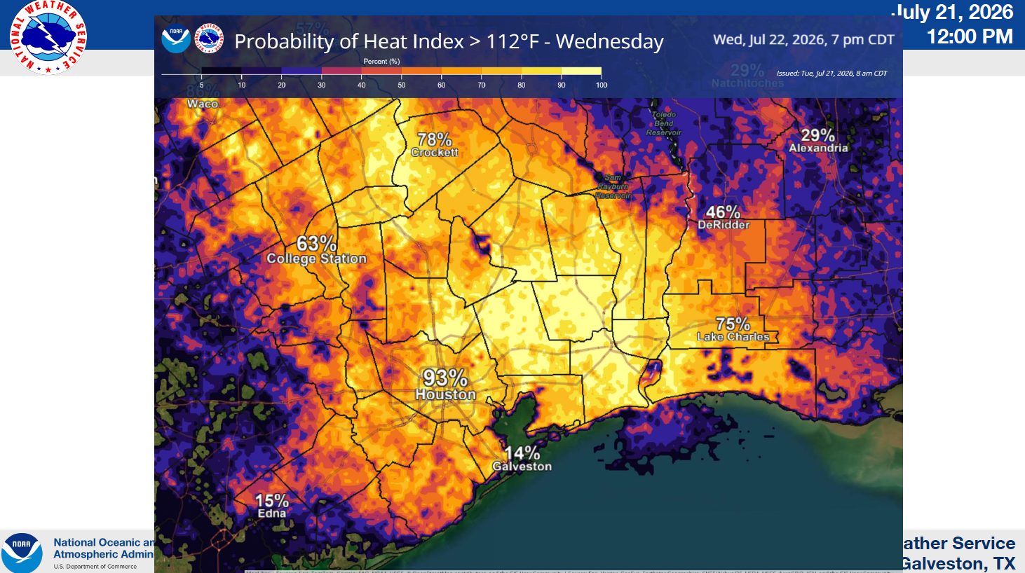
The more immediate weather threat is the dangerous heat already settling across the area. Temperatures near 100 degrees and heat index values potentially reaching 108 to 114 degrees Wednesday and Thursday could make routine outdoor activities hazardous, especially for children, older adults, outdoor workers and people without reliable air conditioning.
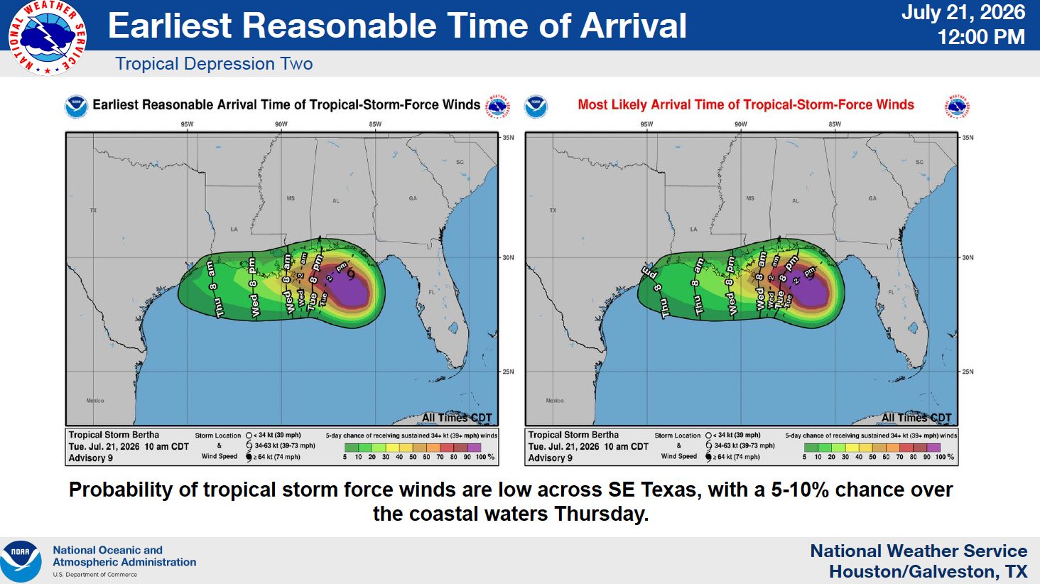
The National Weather Service Houston/Galveston said Tuesday that Bertha’s heavy rainfall threat has diminished and that the chance of tropical-storm-force winds remains low across Southeast Texas. Forecasters are still urging residents to monitor updates because tropical forecasts can change as a system moves across the Gulf.
What Tropical Storm Bertha Could Bring to Southeast Texas
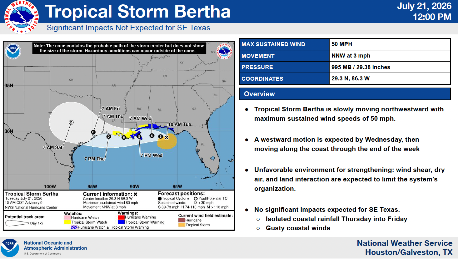
As of the National Weather Service’s noon briefing Tuesday, July 21, Tropical Storm Bertha had maximum sustained winds of 50 mph and was moving north-northwest at 3 mph. Its central pressure was measured at 995 millibars.
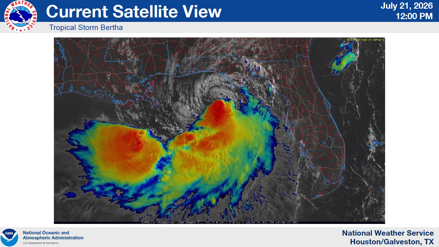
Bertha is expected to turn westward by Wednesday and continue moving along the central Gulf Coast through the end of the week. However, dry air, strong wind shear and interaction with land are expected to disrupt the storm’s organization and limit additional strengthening as it moves closer to the western Gulf Coast.
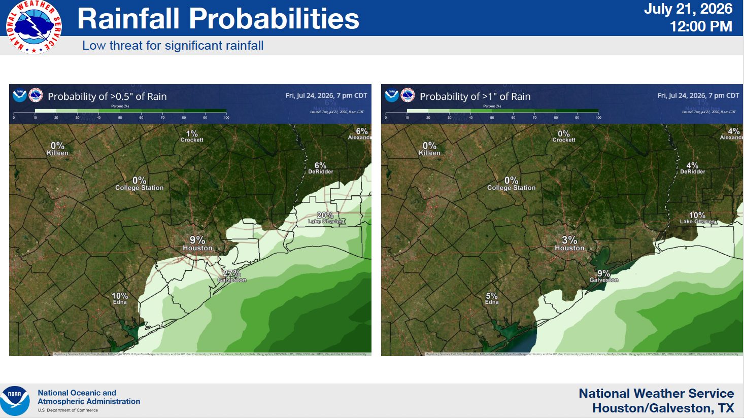
The National Weather Service said significant impacts are not expected for Southeast Texas under the current forecast. The region could still see isolated coastal rainfall Thursday into Friday and gusty winds near the coast.
The chance of tropical-storm-force winds is estimated at only 5% to 10% over coastal waters Thursday, with little to no chance across inland communities. Forecasters are also not anticipating significant coastal flooding or abnormal tide impacts.
The National Weather Service Houston/Galveston’s latest tropical forecast similarly indicates that wind shear, dry air and land interaction should limit Bertha’s organization as it approaches Southeast Texas.
Heavy Rainfall Threat Continues to Decrease
For residents concerned about street flooding, swollen bayous or water entering low-lying neighborhoods, the latest outlook is encouraging.
Rainfall probabilities remain low across most of Southeast Texas, and the National Weather Service no longer expects a widespread heavy rainfall event from Bertha. Coastal communities may receive isolated rain as the system moves west, but the current forecast does not point to significant inland flooding.
That assessment is notably different from earlier forecasts for the system, when Tropical Depression Two carried greater uncertainty about its possible rainfall and wind impacts. Bertha’s organization and surrounding atmospheric conditions have since become clearer, allowing forecasters to reduce the expected threat for the Houston area.
Extreme Heat Is the Greater Immediate Concern
While Bertha remains a system to watch, dangerous heat is expected to have a broader effect on residents across Southeast Texas.
An Extreme Heat Warning is expected Wednesday, following Tuesday’s Heat Advisory. Additional Heat Advisories will likely be needed Thursday.
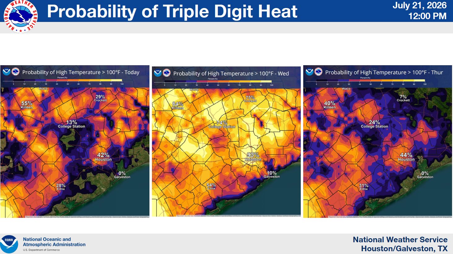
High temperatures are forecast to approach 100 degrees across inland areas through Thursday. Heat index values are expected to remain in the triple digits throughout the week, potentially reaching 108 to 114 degrees Wednesday and Thursday.
Those conditions can cause heat exhaustion or heat stroke more quickly than many people realize. Even residents accustomed to Houston summer weather should take the forecast seriously, particularly during the hottest period of the day.
The National Weather Service recommends reducing time outdoors between 10 a.m. and 6 p.m., drinking water regularly, wearing lightweight and light-colored clothing, and taking frequent breaks in air-conditioned spaces. Residents are also encouraged to check on older neighbors, young children and anyone who may be especially sensitive to heat.
Pets should never be left in parked vehicles, even briefly, and outdoor walking times should be moved to the early morning or later evening when pavement and air temperatures are lower.

What Residents Should Do Now
Southeast Texas residents do not need to make major storm preparations based on the current Bertha forecast, but this is a good time to review basic hurricane-season plans and make sure weather alerts are enabled. Review the NWS Houston/Galveston 2026 Hurricane Guide here.
Coastal residents, boaters and people with plans near Galveston Bay or the Gulf should pay closer attention to updated marine forecasts because gusty winds and changing water conditions may develop even when inland impacts remain minimal.
For most households, the practical priority over the next several days will be limiting heat exposure, checking on vulnerable family members and neighbors, and keeping children and pets safe during the hottest afternoon hours.
Residents should continue following official National Weather Service and National Hurricane Center forecasts as Tropical Storm Bertha moves westward.

 Tiffany Krenek has been on the My Neighborhood News team since August 2021. She is passionate about curating and sharing content that enriches the lives of our readers in a personal, meaningful way. A loving mother and wife, Tiffany and her family live in the West Houston/Cypress region.