Red Flag Warning and Wind Advisory Issued for Harris County Amid Fire Weather Concerns
The Harris County Office of Homeland Security & Emergency Management (HCOHSEM) has issued an alert as the National Weather Service (NWS) places Harris County under a Red Flag Warning and a Wind Advisory. The warnings signal an increased risk of wildfires and hazardous weather conditions due to strong winds and dry air moving into the region.
Understanding the Red Flag Warning
The Red Flag Warning is in effect from 10:00 a.m. until 7:00 p.m. today and is issued when critical fire weather conditions are either occurring or imminent. This means a combination of strong winds, low humidity, and warm temperatures can lead to rapid fire spread. While recent rainfall has lowered the immediate risk, the arrival of drier air and high wind speeds could increase fire potential later in the day.
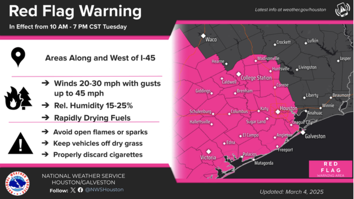
Residents are urged to take the following precautions to prevent wildfires:
-
Avoid open flames, including campfires and burn piles.
-
Properly discard cigarettes and avoid throwing them out of car windows.
-
Do not park vehicles on dry grass, as heat from exhaust systems can ignite fires.
-
Check equipment that could create sparks, such as chainsaws and power tools.
-
Adhere to local burn bans and fire restrictions.
-
Report any signs of fire to local authorities immediately.
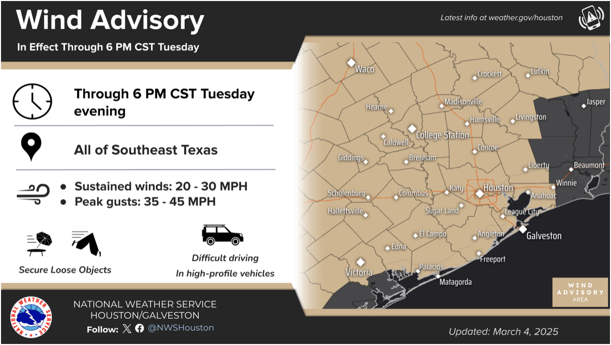
Wind Advisory: High Winds Could Cause Damage
The Wind Advisory remains in effect until 6:00 p.m. today, with sustained winds of 20-30 mph and gusts reaching up to 45 mph across Southeast Texas. Strong winds can lead to downed tree limbs, flying debris, and sporadic power outages.
Safety recommendations during high wind conditions include:
-
Securing outdoor objects like patio furniture, trash bins, and decorations.
-
Driving with caution, especially on bridges and highways.
-
Being prepared for possible power outages by charging devices and securing backup supplies.
Weather Outlook and Additional Hazards
According to the National Weather Service, a cold front moving through Texas is expected to bring strong to severe thunderstorms along and east of I-45. These storms have the potential to produce high winds, hail, and isolated tornadoes, particularly in areas northeast of Houston.
Behind the front, critical fire weather conditions will develop as humidity drops to 15-25%, combining with gusty winds to create an elevated wildfire threat.
Additionally, a Gale Warning is in effect for Galveston Bay and Gulf waters, making marine conditions hazardousfor boaters. Residents along coastal areas should remain aware of changing conditions and avoid unnecessary water activities.
Community Safety is Key
With strong winds, dry air, and increased fire risks, residents must take proactive measures to prevent accidental fires and secure their properties against wind damage. By staying informed and exercising caution, the community can work together to minimize risks and keep Harris County safe during this Red Flag Warning and Wind Advisory event.
 Tiffany Krenek has been on the My Neighborhood News team since August 2021. She is passionate about curating and sharing content that enriches the lives of our readers in a personal, meaningful way. A loving mother and wife, Tiffany and her family live in the West Houston/Cypress region.