







TxDOT Narrows 36A South Highway Study to Three Routes Between Needville and I-10 Near Katy
For families and landowners across Fort Bend County, southern Waller County and the Katy area, the proposed 36A South highway is beginning to look less like a broad planning concept and more like a set of choices with very different consequences.
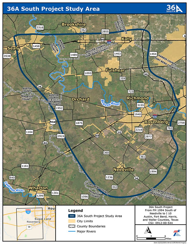
The Texas Department of Transportation has narrowed its study of the approximately 41-mile north-south highway from FM 1994 south of Needville to I-10 west of Katy to three routes: Reasonable Alternatives 4, 8A and 9. The alternatives differ not only in where the highway could run, but also in how much land could be needed, how many homes and businesses could be affected, and whether much of the corridor would be built on a new alignment or elevated above existing roads.
That makes TxDOT's current public meeting period particularly important for people who live, own property, commute or do business between Needville, Rosenberg, Richmond, Fulshear, Katy and surrounding rural communities. No final route has been selected, and the project remains in environmental review.
What Is the 36A South Project?
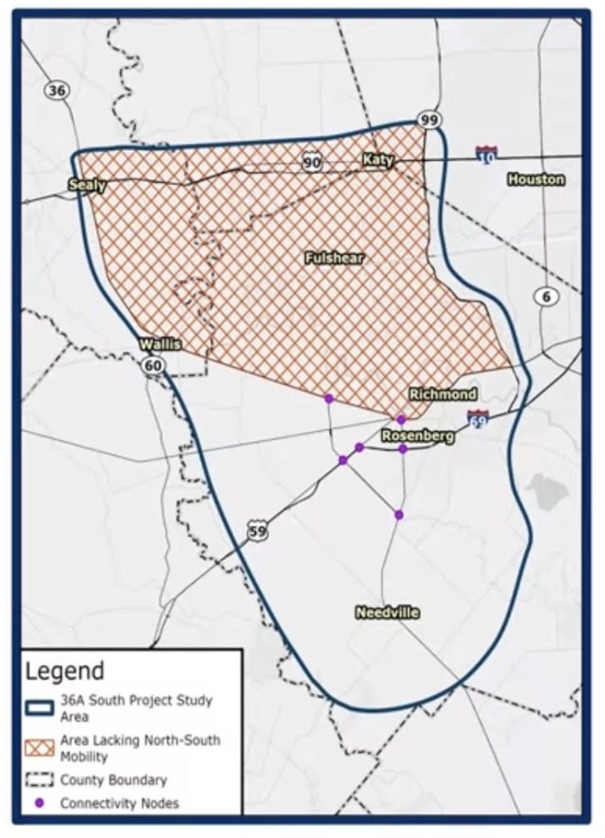
TxDOT says the purpose of the 36A South Project is to improve north-south mobility and connectivity in an area that currently lacks a major continuous north-south highway. The study area stretches from FM 1994 south of Needville north to I-10 west of Katy and covers portions of Fort Bend and Waller counties.
The concept is part of the broader 36A transportation planning effort taking shape west and southwest of Houston. A separate 36A North Project, currently undergoing its own environmental study, would examine a potential connection from I-10 west of Katy to US 290 west of Waller. Together, the studies are examining north-south transportation needs across a rapidly changing part of the Houston region, although each project is being evaluated separately.
For 36A South, TxDOT's current project materials identify funding as still to be determined, reinforcing that the proposal remains in the planning and environmental-review stage rather than being a funded construction project.

Three Alternatives Remain — and Their Impacts Are Quite Different
Perhaps the most important information for residents in the latest 36A South materials is how differently the three remaining alternatives could affect property.
According to TxDOT, Reasonable Alternative 4 would require approximately 3,091 acres of additional right-of-way. Desktop assessments indicate it could potentially displace 23 residences — including 13 single-family homes and 10 mobile homes — along with two non-residential structures.
Reasonable Alternative 8A would require approximately 2,659 acres of right-of-way and carries the highest estimated residential displacement of the three. TxDOT identifies 36 potential residential displacements, including 24 single-family homes, 10 mobile homes and two multifamily homes, as well as six potential commercial or non-residential displacements.
Reasonable Alternative 9, meanwhile, would require considerably less additional land — approximately 1,295 acres. TxDOT estimates it could potentially affect 25 residences, including 21 single-family homes and four mobile homes, along with eight commercial or non-residential properties.
Those numbers are preliminary and based on desktop assessments, not final property acquisition decisions. Final impacts could change as engineering and environmental work advances. TxDOT says relocation assistance would be available for displaced residents and businesses if the project ultimately moves forward.
For homeowners and business owners, that distinction matters: a line appearing within a study alternative does not mean a property has been condemned or that acquisition is imminent. The project has not reached that stage.
Property owners seeking more information about potential right-of-way acquisition or TxDOT's Relocation Assistance Program may contact TxDOT Right-of-Way Project Manager Angelica Sizemore at 713-802-5740. TxDOT says information is available about relocation services and benefits for displaced residents and businesses, as well as the tentative schedule for right-of-way acquisition.
Alternatives 4 and 8A Would Build a New Highway Corridor
Reasonable Alternatives 4 and 8A generally represent the more traditional version of a new 36A South highway.
TxDOT's conceptual design shows a divided highway with four 12-foot travel lanes — two in each direction — separated by a 64-foot grassy median, along with inside and outside shoulders. A 10-foot shared-use path would also be included for pedestrians, cyclists and other non-motorized users.
TxDOT's proposed typical section for Alternatives 4 and 8A shows a conceptual right-of-way width of approximately 450 feet, allowing space not only for the main lanes and median but also for potential intermittent frontage roads. TxDOT notes that those frontage roads are not part of the conceptual typical section and could be constructed by others.
That wider footprint helps explain why Alternatives 4 and 8A require substantially more new right-of-way than Alternative 9.
 (Source: TxDOT)
Alternative 9 Takes a Different Approach: Go Up Instead of Out
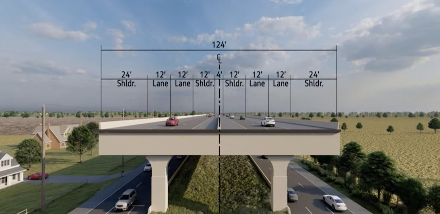
Reasonable Alternative 9 stands apart from the other two options because parts of it would make use of existing SH 36 and Spur 10 corridors, placing the proposed highway above portions of the current roadway rather than carving an entirely new corridor through the landscape.
TxDOT's conceptual plans show an elevated four-lane highway, with two lanes traveling in each direction. Depending on the segment, support columns could be placed within the existing roadway median or outside the existing pavement.
Along several sections, the existing SH 36 or Spur 10 roadway beneath the elevated facility would remain in its current configuration.
That design comes with a tradeoff. Unlike Alternatives 4 and 8A, the elevated Alternative 9 sections shown in TxDOT's current materials would not include intermittent frontage roads or a shared-use path.
It would, however, require less than half the proposed right-of-way identified for Alternative 4 — one reason Alternative 9 may draw particular attention from property owners as residents begin comparing the choices.
Why TxDOT Narrowed the Field
The current three routes emerged from a much larger group of possibilities.
During public scoping in summer 2025, TxDOT presented eight preliminary alternatives for the 36A South corridor. The agency then compared the routes using factors including route length, bridge needs, travel time, compatibility with regional planning, future residential development conflicts, roadway geometry, access roads, intersections and the length and angle of the proposed Brazos River crossing.
Following its review of the preliminary alternatives, TxDOT has narrowed the project to three reasonable alternatives — 4, 8A and 9 — for further study and public comment. The current materials identify the remaining options as 4, 8A and 9.
The narrowing of alternatives does not amount to selection of a preferred route. Instead, it focuses the environmental and engineering analysis — and gives residents a clearer picture of the corridors most likely to receive further study.

The Brazos River, Wetlands and Floodplain Are Part of the Review
Building a major north-south highway through Fort Bend County also means dealing with the region's natural geography.
TxDOT states that the proposed 36A South project would involve construction in wetlands and an action within a floodplain. Environmental documentation, natural and human constraints maps, schematics and other project materials are available as part of the public meeting process.
The Brazos River is another significant piece of the engineering puzzle. Earlier screening of the preliminary alternatives compared potential crossings that varied substantially in length and geometry, illustrating how the river, existing development, road networks and environmental constraints influence where a future corridor could realistically go.
Environmental review for the project is being handled by TxDOT under federal authority delegated through a memorandum of understanding with the Federal Highway Administration.
Katy Meeting Held; Rosenberg Open House Is Aug. 20
TxDOT's virtual 36A South Public Meeting #2 has been available online since Aug. 13 and includes a prerecorded presentation, project exhibits, schematics and other materials.
The first in-person open house was held Tuesday, Aug. 18, at The Katy Gardens, 1040 Schlipf Road in Katy.
Residents who were unable to attend that meeting still have another in-person opportunity:
- Thursday, Aug. 20, 2026
- 5:00 to 7:00 p.m.
- Fort Bend Epicenter
- 28505 Southwest Freeway, Rosenberg, TX 77471
TxDOT says the information provided at the two locations is identical. Attendees can watch the same presentation available online, examine project maps and materials, ask questions and submit written comments in any language.
 (Source: TxDOT)
Residents Have Until Sept. 4 to Submit Comments
For residents who cannot attend either open house, the most important date may be Friday, Sept. 4, 2026.
Comments must be received or postmarked by that date to become part of the official public meeting record.
Comments may be submitted at the meeting, through TxDOT's online comment form, by email to HOU-PIOwebmail@txdot.gov, or by mail to:
TxDOT Houston District Office
Advanced Project Development Department
P.O. Box 1386
Houston, TX 77251-1386
Residents without internet access can call 713-802-5199 between 7 a.m. and 4 p.m. Monday through Friday to ask questions or request access to project materials.
TxDOT says the meetings are conducted in English and Spanish, with interpretation and translation assistance available at no charge.
What Property Owners Should Know Now
There is still a long distance between a conceptual route on a TxDOT map and construction equipment arriving on a property.
The three alternatives are under study, right-of-way estimates remain preliminary, funding has not yet been identified and design details can change as environmental review proceeds.
Still, this stage matters.
For someone whose home, family land, farm, business or future development sits near one of the proposed corridors, the alternatives now being evaluated are substantially more specific than the eight routes presented during the 2025 scoping process.
It is also an opportunity for residents to put information into the formal record that may not be apparent from a map — including drainage history, flooding concerns, neighborhood access, agricultural operations, school travel patterns, planned development, business access and other local conditions.
What Happens Next for 36A South
The next steps will involve continued environmental analysis of the three reasonable alternatives, consideration of public comments and additional engineering work before TxDOT can move toward identifying a preferred alternative or making a final environmental decision.
The agency describes 36A South as an approximately 41-mile proposed transportation corridor intended to improve north-south connections between the Needville area and I-10 west of Katy. It remains a proposal, not an approved highway ready for construction.
For communities along the route, that means the conversation happening now could help shape questions that will follow the project for years: Where should a new regional highway go? How much property should it consume? Which homes and businesses can be avoided? And should parts of the route use an elevated highway along roads that already exist?
Those are no longer abstract questions for parts of Fort Bend and Waller counties. With three alternatives now on the table, residents can see more clearly what each choice could mean for the communities in its path.
My Neighborhood News will continue following the 36A South Project as TxDOT reviews public comments, evaluates Alternatives 4, 8A and 9, and moves toward future environmental and route-selection milestones.

 Tiffany Krenek has been on the My Neighborhood News team since August 2021. She is passionate about curating and sharing content that enriches the lives of our readers in a personal, meaningful way. A loving mother and wife, Tiffany and her family live in the West Houston/Cypress region.