








Gulf Disturbance Could Bring Heavy Rain, Flash Flood Risk Through Wednesday: What Wimbledon Estates Residents Need to Know
Residents across Southeast Texas are heading into the new week with a weather system worth watching closely — not primarily because of its wind potential, but because of the amount of rain it could bring to communities already familiar with how quickly streets, underpasses and low-lying areas can become dangerous.
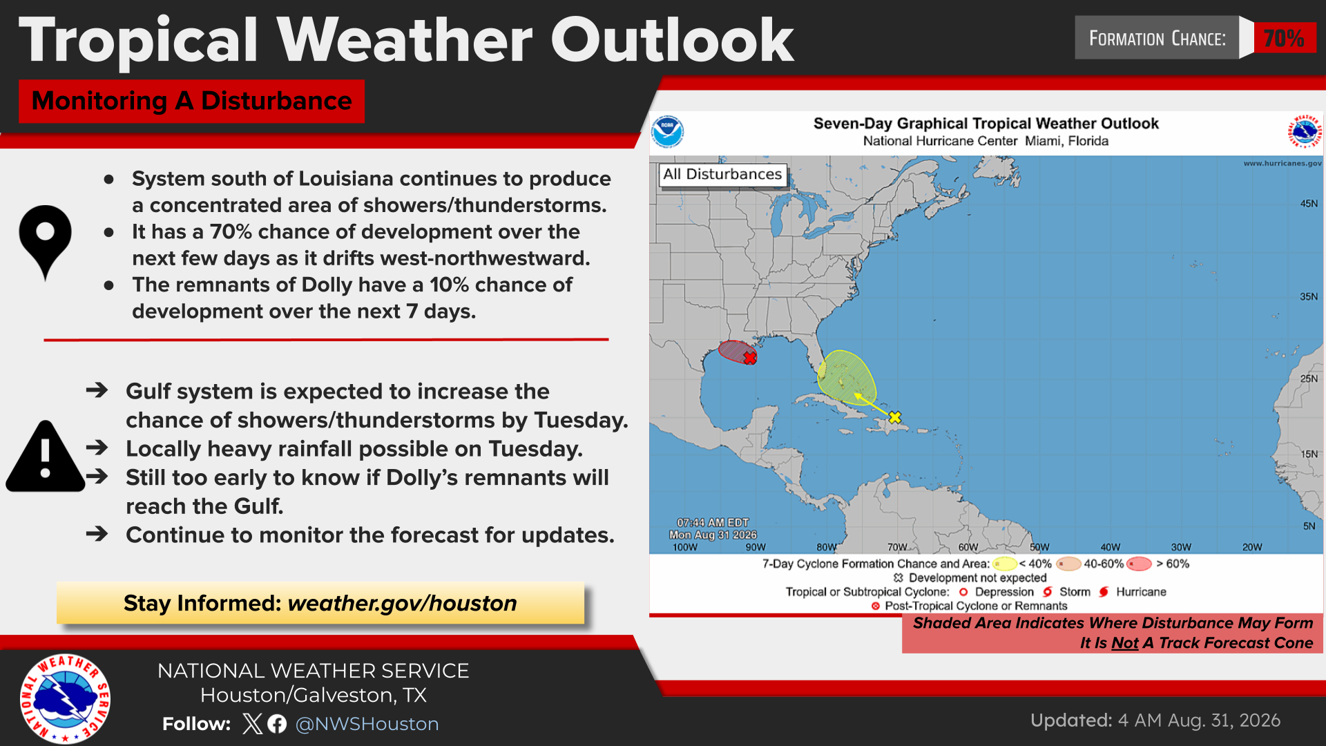
The National Weather Service Houston/Galveston said Monday morning, Aug. 31, that an area of low pressure known as Invest AL97 in the north-central Gulf could develop into a short-lived tropical depression or tropical storm before reaching the Upper Texas or southwestern Louisiana coast Tuesday. The National Hurricane Center placed the system's chance of tropical development at 70%, while emphasizing that heavy rainfall remains a concern regardless of whether the system receives a name.
For families and homeowners in Wimbledon Estates: Tuesday could bring periods of very heavy rainfall, and residents should use Monday to make reasonable preparations, review travel plans and make sure they have reliable ways to receive weather alerts.
Heavy Rain and Flash Flooding Are the Main Concerns
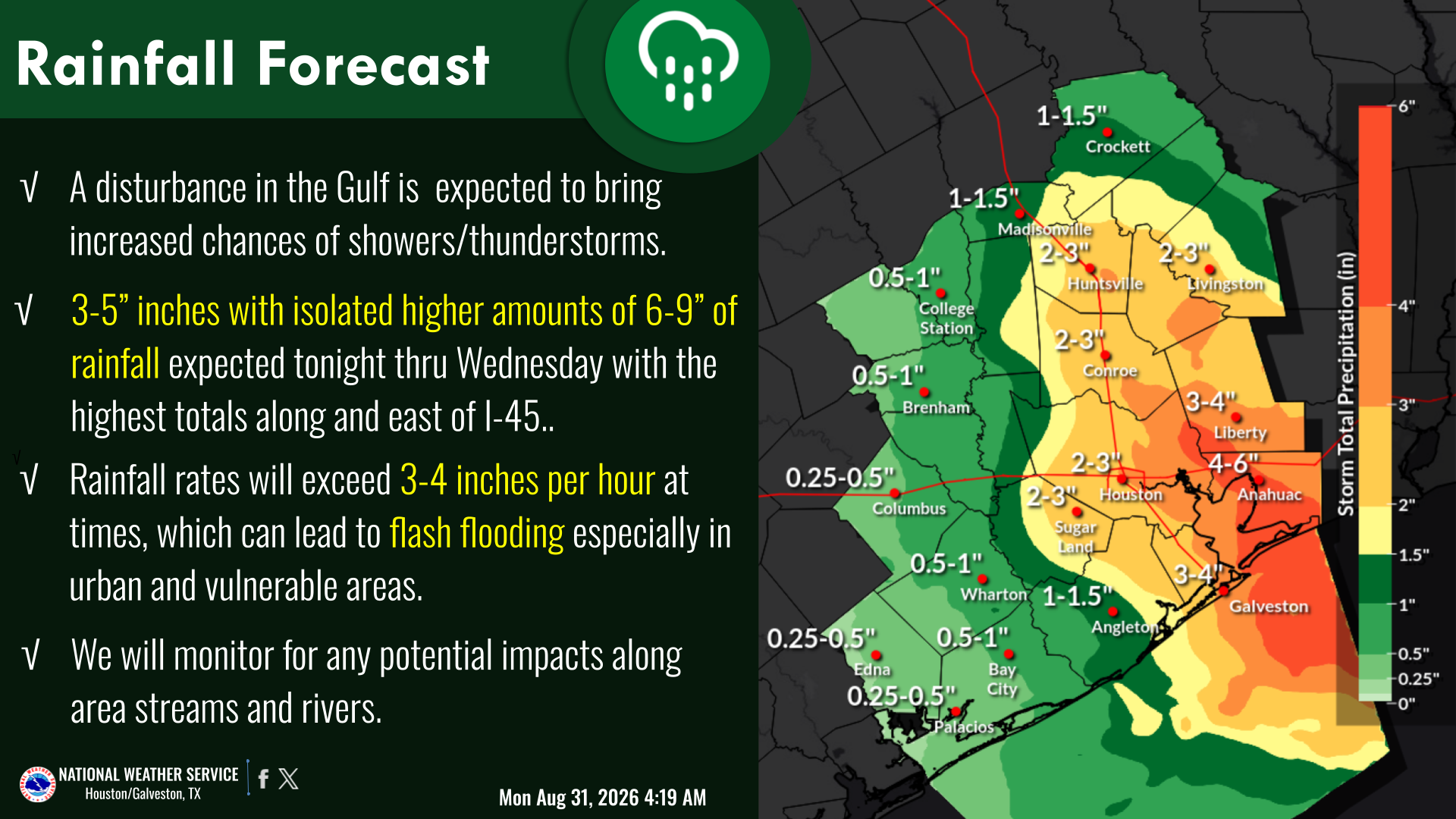
According to the National Weather Service update issued Monday morning, forecast rainfall totals have increased slightly as forecasters continue to evaluate the system.
Current projections call for 3 to 5 inches of rain generally east of Interstate 45, with isolated totals of 6 to 9 inchespossible depending on exactly where the heaviest bands develop and repeatedly move over the same locations.
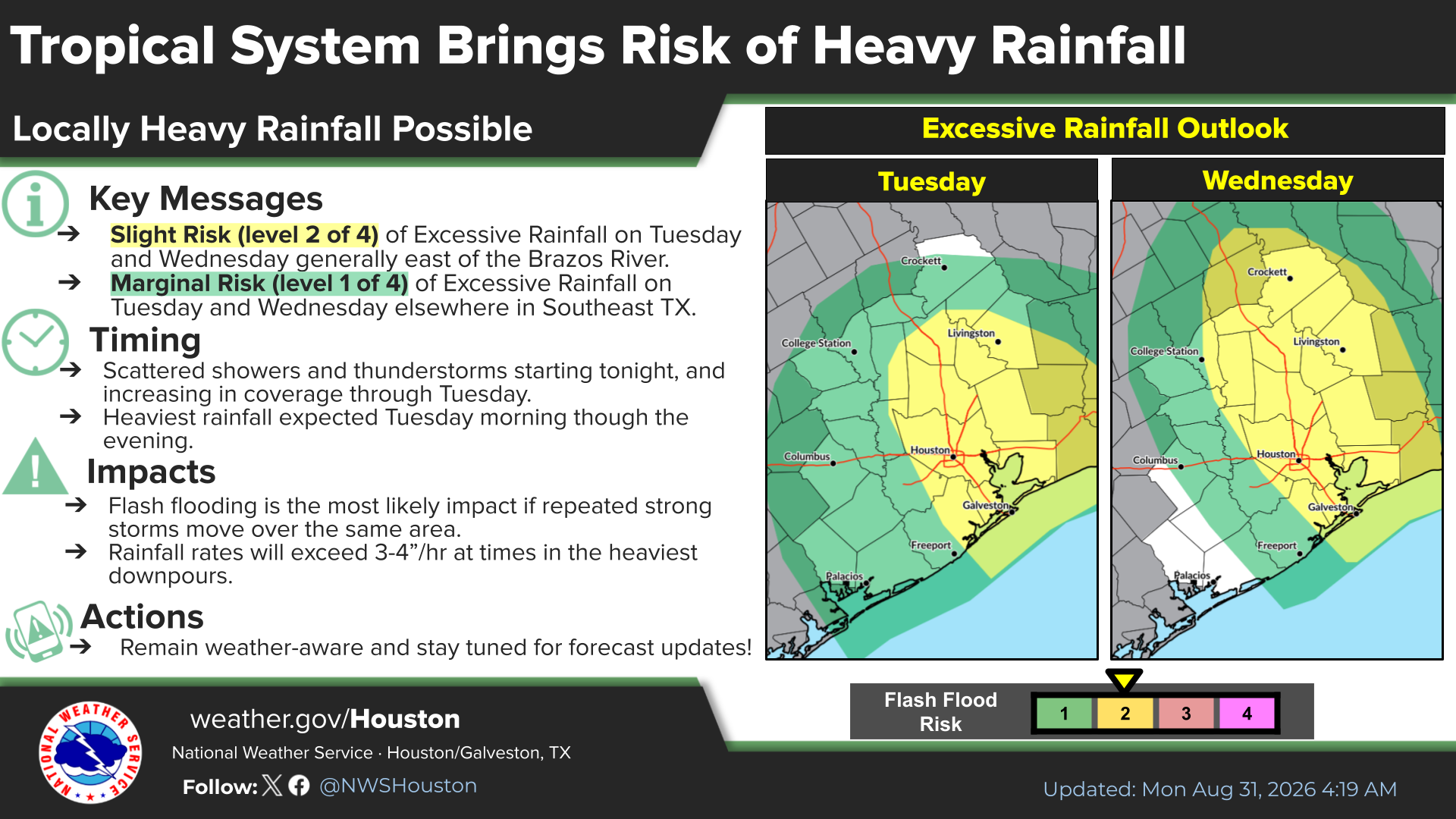
In the strongest tropical downpours, rainfall rates could exceed 3 to 4 inches per hour. That kind of rainfall can overwhelm drainage systems quickly, particularly in urban areas, at underpasses and along low-water crossings.
The Weather Prediction Center has placed portions of Southeast Texas generally east of the Brazos River under a Slight Risk, Level 2 of 4, for excessive rainfall Tuesday and Wednesday. Surrounding portions of the region are under a Marginal Risk, Level 1 of 4.
Scattered showers and thunderstorms are expected to increase beginning late Monday, with the current forecast placing the most significant rainfall period from Tuesday morning through Tuesday evening or Tuesday night.
Forecasters cautioned that those details remain subject to change as the system develops.
Tropical Storm Watches or Warnings Could Be Issued
While flooding is currently considered the greater threat, residents should not completely dismiss the possibility of stronger winds.
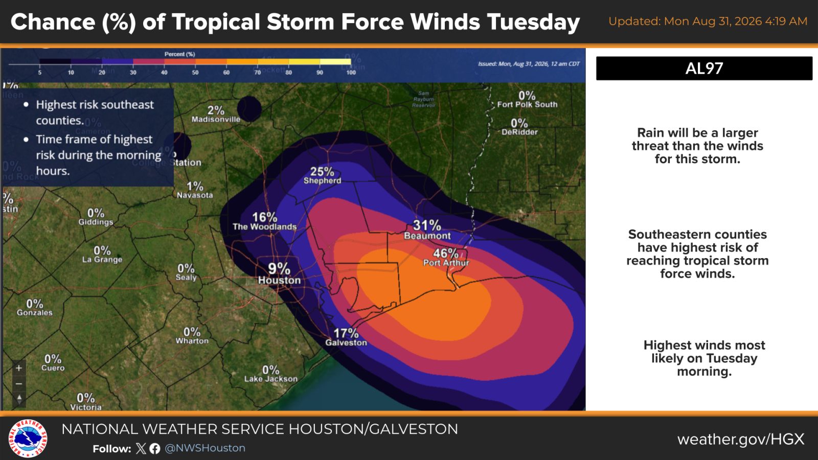
The National Hurricane Center said Monday morning that additional organization of AL97 was expected as the system moved slowly west-northwestward, and tropical storm watches or warnings could be needed for portions of the Upper Texas or southwestern Louisiana coast.
The highest probabilities for tropical-storm-force winds are currently concentrated in southeastern counties and coastal areas. National Weather Service projections showed lower probabilities farther inland, with the most likely period for stronger winds occurring Tuesday morning.
A reconnaissance aircraft was scheduled to investigate AL97 Monday morning. Information collected during that flight could help forecasters determine whether the circulation has strengthened and provide a clearer picture of where the system may move and which areas could see the greatest impacts.
That means residents in Wimbledon Estates should expect forecast adjustments throughout the day rather than treating Monday morning's rainfall map as a final prediction.
What Residents Can Do Before the Rain Arrives
There is no need for panic buying or hurricane-level preparation based on the current forecast, but a few practical steps could make Tuesday considerably easier if storms become persistent.
Residents can charge phones and portable battery packs, enable emergency alerts, secure lightweight outdoor items and clear leaves or debris from nearby storm drains where it can be done safely. Keeping medications, flashlights and basic supplies accessible is also worthwhile in case localized flooding or power interruptions temporarily make travel difficult.
Families may also want to review Tuesday morning commutes, school routes and childcare plans now, particularly if their normal drive includes flood-prone streets, drainage channels or underpasses.
Anyone who must travel during heavy rain should allow additional time and avoid relying solely on familiar routes. A roadway that is normally safe can become impassable within minutes during a tropical downpour.
The National Weather Service continues to emphasize one of the most important flood-safety messages in Southeast Texas: “Turn Around, Don’t Drown.”
Drivers should never attempt to cross a flooded roadway or low-water crossing. Water depth can be difficult to judge, pavement may be damaged beneath the surface, and moving water can carry away a vehicle faster than many people realize.
Urban Areas Could See Problems Develop Quickly
Flood risk often depends as much on rainfall intensity as total accumulation.
A neighborhood receiving several inches slowly over many hours may experience fewer problems than another receiving several inches in a short period. With rainfall rates potentially reaching 3 to 4 inches per hour in the strongest storms, forecasters are particularly concerned about repeated downpours over highly developed areas.
That is why residents should pay attention not only to countywide forecasts but also to Flash Flood Warnings, street flooding reports and local emergency notifications Tuesday.
Those living near creeks, bayous, drainage channels or historically flood-prone roads should monitor conditions more frequently and avoid waiting until water is already rising to reconsider travel.

Air and Marine Travel Could Also Be Affected
The approaching Gulf system could cause disruptions beyond neighborhood streets.
The National Weather Service said aviation conditions could periodically deteriorate to IFR or MVFR levels in and around thunderstorms, with gusty, variable winds possible and shifting wind directions expected as the system moves through Tuesday.
Marine conditions are also expected to worsen late Monday into Tuesday as winds, seas, showers and thunderstorms increase.
Travelers with Tuesday flights may want to monitor airline notifications before leaving home, while boaters and others planning activities along the Upper Texas Coast should closely follow marine forecasts and any advisories that are issued.
What About the Remnants of Dolly?
Forecasters are also monitoring the remnants of Dolly farther east, but the National Hurricane Center has lowered the system's probability of redevelopment to 10%.
At this point, the north-central Gulf disturbance AL97 is the system posing the more immediate concern for Southeast Texas.
What Happens Next
The forecast should become clearer as reconnaissance data, satellite observations and additional weather-model information arrive Monday.
The National Hurricane Center said the disturbance was located a little more than 100 miles south of southern Louisiana Monday morning and continued to show signs of organization while moving slowly west-northwestward toward the Upper Texas or southwestern Louisiana coast.
For Wimbledon Estates, the next 24 to 36 hours are therefore less about watching whether the system gets a name and more about watching where the heaviest rain develops.
Residents should continue monitoring the National Weather Service Houston/Galveston, the National Hurricane Center, local emergency management agencies and trusted local news sources as forecasts and potential watches or warnings are updated.
My Neighborhood News will continue following the Gulf system and its potential impacts across Southeast Texas as new information becomes available.

 Tiffany Krenek has been on the My Neighborhood News team since August 2021. She is passionate about curating and sharing content that enriches the lives of our readers in a personal, meaningful way. A loving mother and wife, Tiffany and her family live in the West Houston/Cypress region.
Local business spotlight
Grow your business
where trust already lives.
Let’s introduce your business to the neighbors nearby.
Have a local favorite?
Let’s make an introduction.
Leave your email and our team will reach out with ways to promote your business.
Give a local favorite a little love.
Know a business your neighbors should discover? Tell us who they are.
We couldn’t send that just yet. Please try again.