
Greater Houston Weather Update: Low Tropical Development Risk in Bay of Campeche, But Rain Chances Increasing for Southeast Texas
As hurricane season gets underway across the Gulf Coast, forecasters are keeping a close eye on a tropical disturbance in the Bay of Campeche that could bring wetter weather to the Greater Houston area in the days ahead.
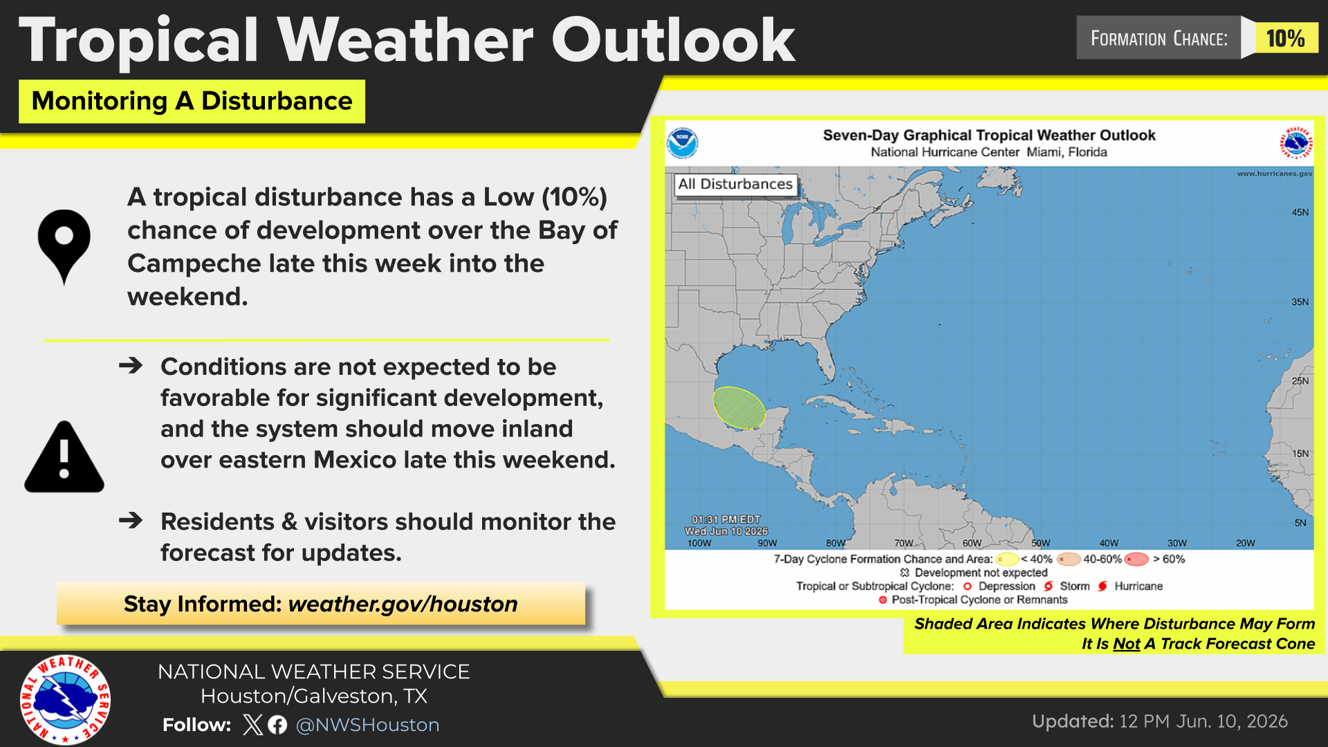
According to the National Weather Service Houston-Galveston and the National Hurricane Center (NHC), a broad area of low pressure may develop late this week over the Bay of Campeche, located in the southwestern Gulf of Mexico near Mexico's eastern coast. At this time, the system has only a 10% chance of tropical development during the next seven days, and forecasters do not expect conditions to support significant strengthening.
For residents across Houston, Cypress, Katy, Tomball, Spring, The Woodlands, Sugar Land, Pearland, Baytown, Galveston and surrounding Southeast Texas communities, the message remains straightforward: there is no immediate cause for concern, but it is a good time to stay informed as the forecast evolves.
What This Means for Greater Houston
Current forecasts indicate that any developing system would likely move inland across eastern Mexico later this weekend rather than into Texas. However, tropical systems do not need to make landfall locally to influence weather conditions hundreds of miles away.
The National Weather Service expects moisture associated with the disturbance to spread northward, increasing rain chances across Southeast Texas from late this weekend into early next week. Some areas could experience periods of locally heavy rainfall.
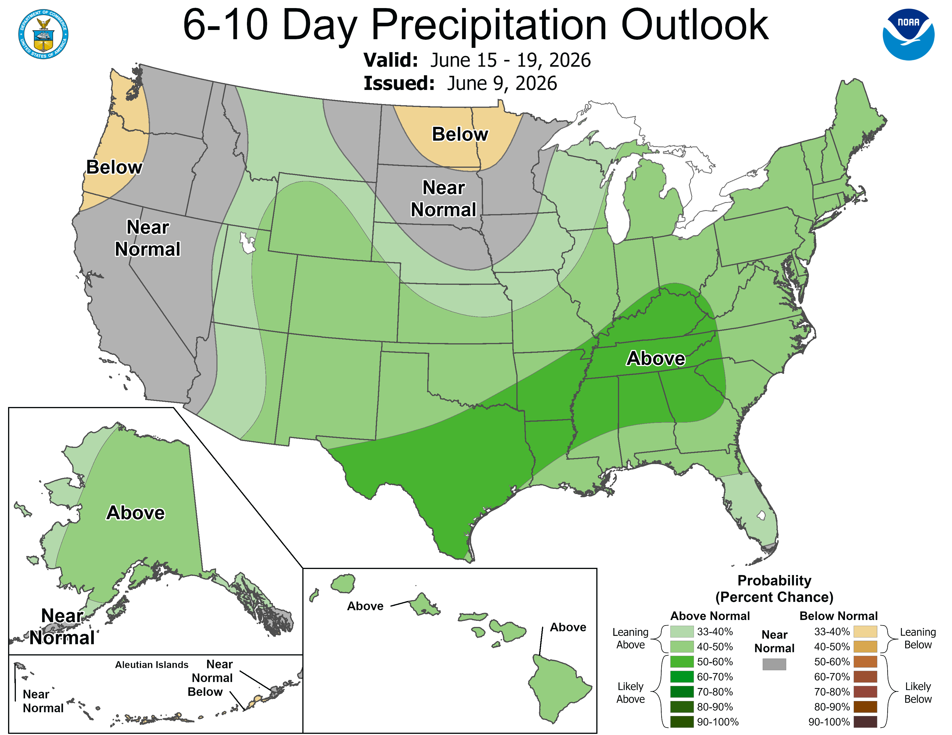
Adding confidence to that outlook, NOAA's latest 6-to-10-day precipitation forecast shows much of Texas and the Gulf Coast region favored for above-normal rainfall through the middle of next week.
While widespread flooding is not currently forecast, residents should monitor updates, especially in locations prone to poor drainage or localized street flooding during heavy downpours.
Hurricane Season Has Begun, Even During a Quieter Forecast Year
The update also serves as a reminder that the Atlantic hurricane season officially runs from June 1 through November 30, with the greatest threat to Texas typically occurring during August and September.
Earlier this month, NOAA released its 2026 Atlantic Hurricane Season Outlook, forecasting a below-normal season overall, with a 55% chance of below-normal activity, a 35% chance of a near-normal season and only a 10% chance of an above-normal season.
Forecasters predict:
- 8 to 14 named storms
- 3 to 6 hurricanes
- 1 to 3 major hurricanes
Even so, meteorologists continue to emphasize an important message for Gulf Coast residents: a quiet season does not eliminate local risk.
The National Weather Service's 2026 Southeast Texas Hurricane Guide notes that hurricane preparedness should never be based solely on seasonal forecasts because "it only takes one" storm to create significant impacts for local communities.
A Good Time to Review Hurricane Preparedness Plans
With the first tropical disturbance of the season now being monitored near the Gulf, emergency managers encourage residents to use this period of relatively calm weather to review preparedness plans.
The National Weather Service recommends:
- Knowing whether your home is located in an evacuation zone.
- Building a hurricane supply kit with at least seven days of food, water and medications.
- Ensuring important documents are protected and easily accessible.
- Including pets in emergency planning.
- Following trusted weather sources throughout hurricane season.
The 2026 Southeast Texas Hurricane Guide also reminds residents that inland flooding often becomes one of the most significant threats associated with tropical systems and urges drivers to remember the familiar warning: "Turn Around, Don't Drown."
What Happens Next?
Forecasters will continue monitoring conditions in the Bay of Campeche through the weekend. While development remains unlikely, residents are encouraged to check the latest updates from the National Hurricane Center and National Weather Service Houston-Galveston, particularly as rain chances increase across the region.
For now, Greater Houston residents can expect a typical early-season tropical setup: low development potential, rising Gulf moisture and a good reminder that hurricane preparedness is a season-long commitment.
 Tiffany Krenek has been on the My Neighborhood News team since August 2021. She is passionate about curating and sharing content that enriches the lives of our readers in a personal, meaningful way. A loving mother and wife, Tiffany and her family live in the West Houston/Cypress region.