Flash Flood Warnings Issued as Greater Houston Faces Life-Threatening Flood Risk Through Thursday
Heavy rain is no longer just a forecast for the Greater Houston area. By midday Monday, June 15, the National Weather Service Houston/Galveston had issued Flash Flood Warnings and Flood Advisories for parts of Harris, Montgomery and Liberty counties as thunderstorms dropped several inches of rain and created dangerous conditions on streets, highways, underpasses and low-lying areas.
For residents across Houston, Humble, Kingwood, Spring, Atascocita, Bellaire, Missouri City, The Woodlands-area communities, New Caney, Porter, Liberty County and the broader Southeast Texas region, the message from forecasters and emergency officials is urgent: stay weather aware, avoid unnecessary travel during heavy rain, and never drive into flooded roadways.
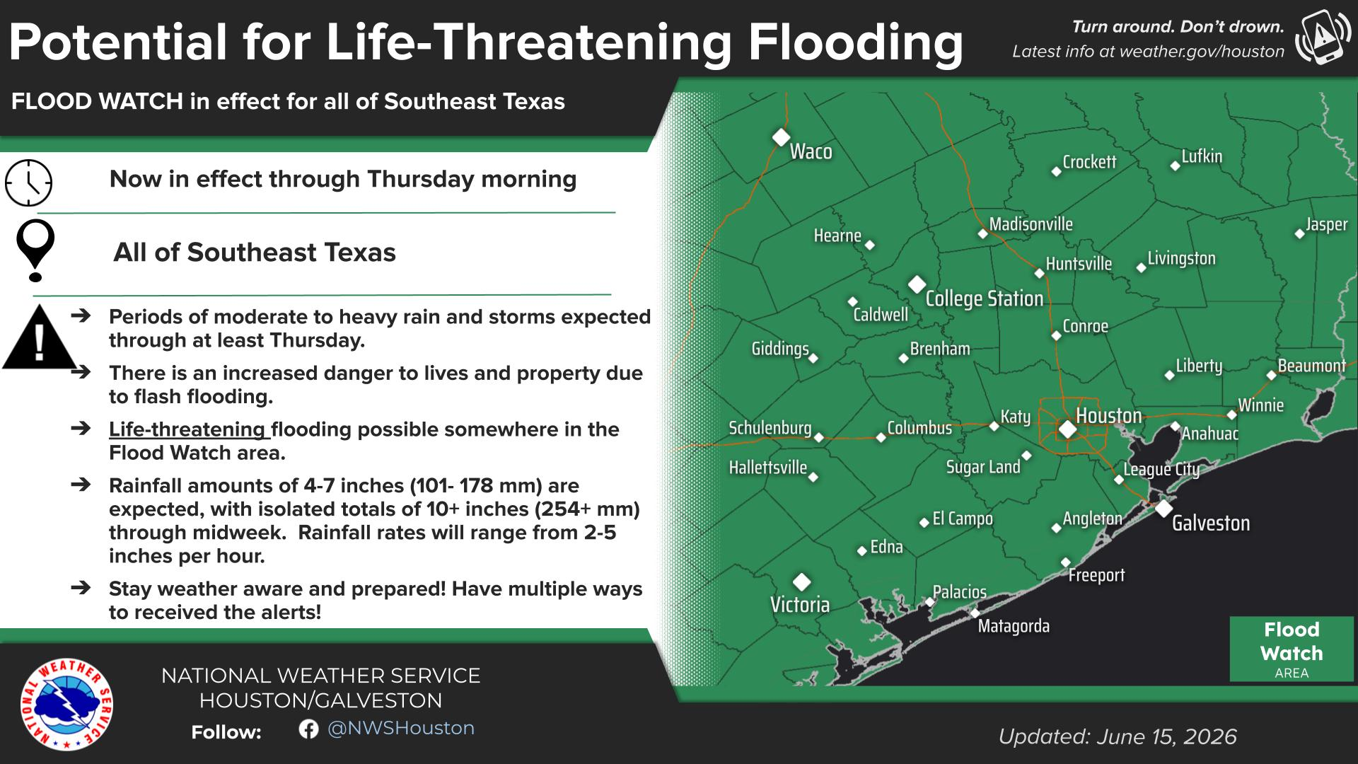
A Flood Watch remains in effect through Thursday morning for a wide portion of Southeast Texas and parts of south central Texas, with the National Weather Service warning of the “potential for life-threatening flash flooding.”
Flash Flood Warnings Issued for Harris and Montgomery Counties
The National Weather Service issued Flash Flood Warnings Monday for Harris County and southeastern Montgomery County after Doppler radar and automated rain gauges showed thunderstorms producing heavy rainfall across the warned area.
Between 2 and 3 inches of rain had already fallen in some areas, with rainfall rates expected to reach 2 to 4 inches in one hour. Additional rainfall of 1 to 3 inches was possible in the warned area, according to forecasters.
Locations identified in the warning included Humble, Kingwood, Spring, Roman Forest, Woodbranch, Atascocita, Lake Houston, eastern Bush Intercontinental Airport, Porter Heights, East Little York/Homestead, Hurricane Harbor Splashtown, East Houston, Houston Gardens, Porter and New Caney.
Earlier Monday, a separate Flash Flood Warning was issued for Harris County, including areas such as northern Missouri City, Bellaire, West University Place, Jersey Village, Greater Heights, Spring Branch, Memorial Park, Northside/Northline, River Oaks, Aldine, Greater Greenspoint and Montrose.
Flood Advisories Add to Growing Concerns
Flood Advisories were also issued for Harris, Liberty and Montgomery counties, where forecasters said minor flooding was ongoing or expected to begin shortly in low-lying and poor drainage areas.
In some advisory areas, between 2 and 4 inches of rain had already fallen, with another 1 to 3 inches expected. Earlier in Harris County, forecasters reported 1 to 2 inches of rainfall, with additional rain likely to cause urban and small stream flooding. Some low-water crossings could become impassable.
These advisories matter because minor flooding can quickly become dangerous when rain continues to fall over the same neighborhoods, especially in areas with poor drainage, bayous, creeks, underpasses and roads that regularly hold water.
Flood Watch Continues Across Southeast Texas
The broader Flood Watch remains in effect through Thursday morning for a large area that includes Harris, Fort Bend, Montgomery, Brazoria, Galveston, Chambers, Liberty, Waller, Wharton, Austin, Matagorda, Washington, Brazos, Walker, San Jacinto, Polk, Trinity and surrounding counties.
The watch also includes communities such as Houston, Sugar Land, First Colony, Rosenberg, Missouri City, Pearland, Friendswood, League City, Galveston, Baytown, Pasadena, Katy, The Woodlands, Conroe, Cleveland, Brenham, College Station, Bryan, Bay City, Angleton, Freeport, Lake Jackson, Alvin and many others.
According to the National Weather Service, northern portions of the watch area have already received 4 to 6 inches of rain. An additional 4 to 7 inches of rain is expected across the region, with isolated totals of more than 10 inches possible through midweek.
Why Residents Should Take This Seriously
This is the kind of weather setup that can change quickly from inconvenient to dangerous.
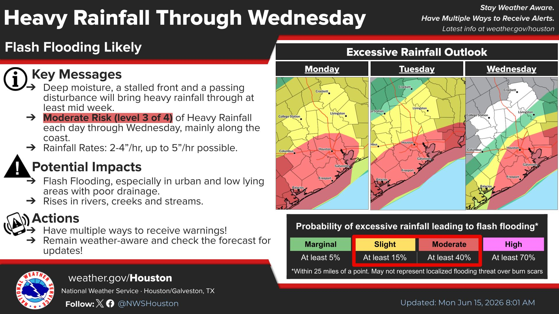
Forecasters say excessive runoff may cause flooding of rivers, creeks, streams, bayous, streets and other flood-prone locations. Urban areas are especially vulnerable when rain falls at rates of 2 to 4 inches per hour, because drainage systems can become overwhelmed in a short period of time.
The National Weather Service has also warned that flash flooding is likely and considerable flash flooding is possible. That means residents should be prepared for additional Flood Warnings or Flash Flood Warnings as storms continue moving through Southeast Texas.
Watch vs. Warning: Know the Difference
A Flood Watch means flooding is possible and residents should be prepared.
A Flood Warning or Flash Flood Warning means flooding is happening or expected to begin soon, and people in the affected area should take action immediately.
For families, commuters and business owners across Greater Houston, that distinction matters. A watch is the time to prepare. A warning is the time to act.
ReadyHarris Urges Multiple Ways to Receive Alerts
The Harris County Office of Homeland Security & Emergency Management is encouraging residents to stay informed through official sources, including ReadyHarris Alerts, ReadyHarris Accessible Alerts, the National Weather Service, local media and Wireless Emergency Alerts on mobile phones.
Residents are also encouraged to check the Harris County Flood Control District Flood Warning System for real-time waterway conditions and Houston TranStar for live traffic and road conditions before driving.
With heavy rain expected to continue in waves, conditions may vary widely by neighborhood. One area may see manageable rain while another nearby community experiences fast-rising water.
Travel Could Become Dangerous Quickly
Officials continue to stress one of the most important flood safety messages in Texas: Turn Around, Don’t Drown.
Most flood deaths occur in vehicles. Floodwater can hide washed-out pavement, debris, stalled vehicles or water that is much deeper than it appears. Drivers should not attempt to cross flooded streets, underpasses, low-water crossings or feeder roads.
Residents who do not need to travel during periods of heavy rain are encouraged to stay off the roads until conditions improve.
FIFA World Cup Fan Festival Closed Monday
The weather threat has already affected major activities in Houston.
The City of Houston announced that the FIFA World Cup 2026 Fan Festival would be closed Monday, June 15, because of the weather. Residents and visitors are encouraged to monitor official FWC26 Houston social media channels and the event website for updates.
The closure is a reminder that this weather event may affect more than traffic. Outdoor plans, summer activities, youth sports, work commutes and community events could all be impacted as the week continues.
Tropical Disturbance Being Monitored
The National Hurricane Center is also watching a trough of low pressure near northeastern Mexico. Tropical development is not expected immediately, but the system could move northeast and re-emerge over the northwestern Gulf of America late Tuesday or Wednesday.
Formation chances remain low, but forecasters said heavy rainfall, flash flooding and gusty winds are possible across portions of eastern and southern Texas and Louisiana regardless of whether a tropical cyclone forms.
What Residents Should Do Now
Residents across Greater Houston and Southeast Texas should keep phones charged, enable Wireless Emergency Alerts, monitor official weather updates, avoid flooded roads, check on neighbors who may need help and be ready to change travel plans quickly.
Those living near bayous, creeks, rivers or low-lying streets should pay especially close attention to new warnings and be prepared to act if flooding develops.
What Happens Next
Rain and thunderstorms are expected to continue through at least midweek, with the Flood Watch currently in effect through Thursday morning. Additional warnings may be issued as storms develop and move across the region.
For now, officials are asking residents to take the threat seriously, stay close to trusted weather sources and make safety the priority.
Stay tuned to My Neighborhood News for continuing weather updates affecting Greater Houston, Southeast Texas and surrounding communities.
 Tiffany Krenek has been on the My Neighborhood News team since August 2021. She is passionate about curating and sharing content that enriches the lives of our readers in a personal, meaningful way. A loving mother and wife, Tiffany and her family live in the West Houston/Cypress region.