







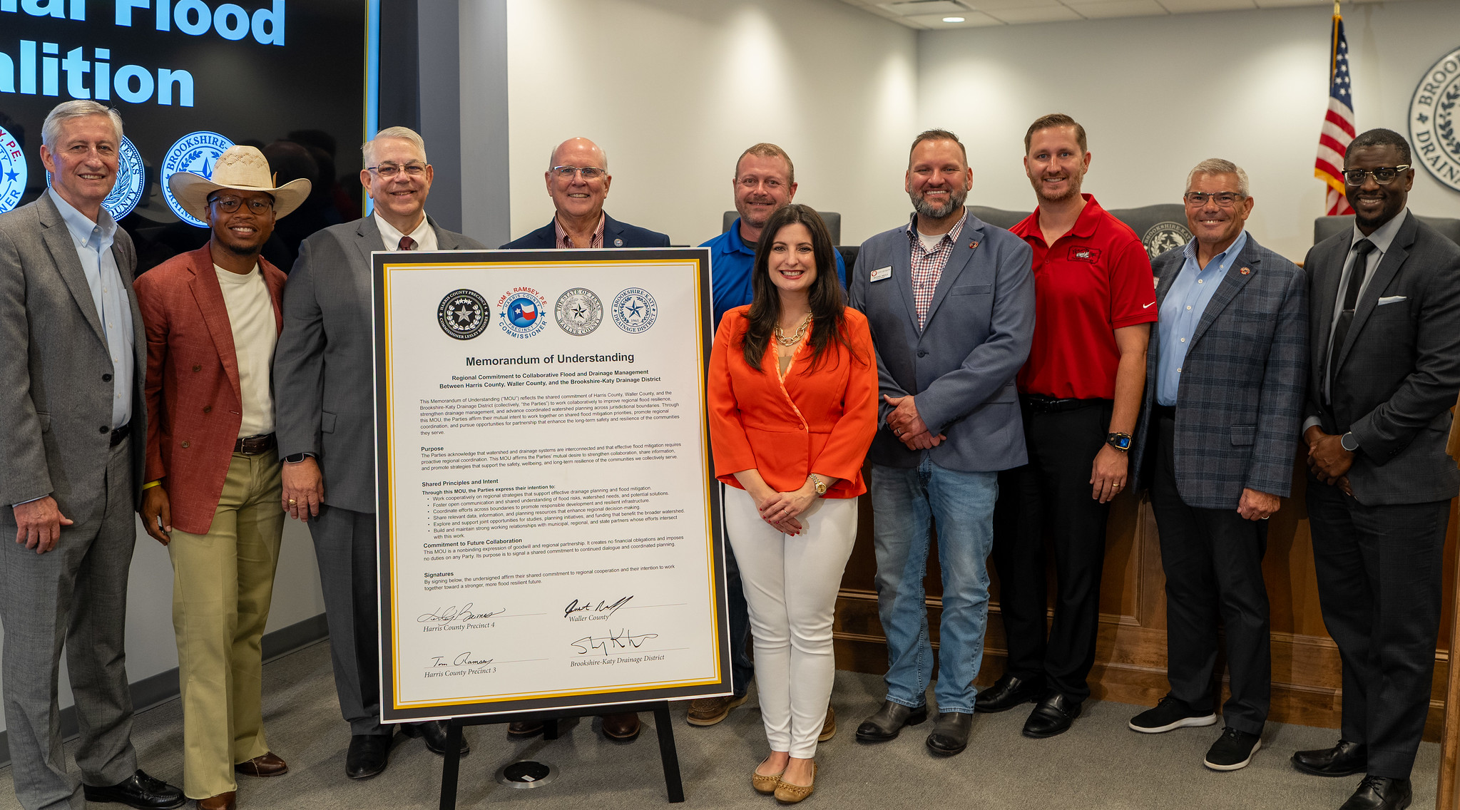
Harris and Waller Counties Launch Regional Coalition to Coordinate Flood Protection Across County Lines
When heavy rain falls near the Harris-Waller county line, the water does not remain neatly within one government’s jurisdiction. It moves through creeks, channels, detention systems and neighboring communities—sometimes creating consequences miles downstream.
Leaders from Harris County, Waller County, the Harris County Flood Control District, the City of Katy and the Brookshire-Katy Drainage District are now formalizing a regional approach to that shared challenge.
Harris County Precinct 4 Commissioner Lesley Briones joined Harris County Precinct 3 Commissioner Tom Ramsey, Waller County Precinct 4 Commissioner Justin Beckendorff and other regional leaders Sept. 1 to launch a flood resiliency coalition intended to improve coordination, share information and advance flood-protection efforts across county and jurisdictional lines.
The participating agencies say the partnership could benefit more than 1 million people in Harris and Waller counties, including residents in some of the state’s fastest-growing communities.
“Flooding doesn't stop at a county line, and after Harvey, neither can we,” Briones said. “For too long, we've protected our communities in silos, county by county, storm by storm, while the water moved freely across every boundary we drew. That has to change.”
What will the regional flood resiliency coalition do?
The coalition’s initial priorities include studying how water moves between Harris and Waller counties, coordinating improvements in the Cane Island area and exploring a more connected regional flood-warning system.
The participating entities plan to work on:
- A Cypress Creek study examining how water flows between the two counties
- Coordinated drainage and detention improvements in the Cane Island area
- Additional flood-monitoring gauges and a possible regional warning system
- Regional drainage standards and best practices for rapidly developing areas
- Greater sharing of flood-risk data, watershed information and planning resources
- Joint studies, infrastructure planning and potential funding opportunities
The formal agreement also recognizes that decisions made upstream can affect homes, roads and drainage infrastructure downstream. According to the coalition announcement, 43 people lost their lives and more than 160,000 homes in Harris and Waller counties were damaged during Hurricane Harvey and the 2016 Tax Day floods.
Ramsey said Harris County’s experiences with hurricanes and major floods have demonstrated why neighboring jurisdictions need to learn from one another and coordinate their standards.
“You don't get to lecture on partnership if you're not willing to practice it,” Ramsey said. “Not every county along our border shares the same drainage standards, not because we're smarter, but because Harris County has made more mistakes than anybody and learned from everyone, from Carla to Ike to Harvey.”

Agreement was advancing before the September launch
Brookshire-Katy Drainage District records show that the regional agreement had been moving through the approval process for several months before the public launch.
According to public meeting minutes, on June 8, 2026, the district’s Board of Supervisors unanimously approved the memorandum of understanding and authorized General Manager Stan Kitzman to execute it. The document identifies five formal parties: Harris County, the Harris County Flood Control District, Waller County, the City of Katy and the Brookshire-Katy Drainage District.
Under the agreement, the agencies intend to coordinate regional drainage and flood-mitigation strategies, share data and planning resources, support resilient infrastructure and responsible development, and explore joint studies and funding opportunities.
The memorandum is a framework for cooperation rather than a construction or funding agreement. It expressly states that it is nonbinding, creates no financial obligations and imposes no duties on the participating entities. That means individual studies, warning-system expansions and infrastructure projects will still require additional planning, funding and government approvals.
For residents, that distinction is important: the coalition does not mean that all of the proposed improvements are immediately funded or ready for construction. It establishes the working relationship needed for agencies to develop those projects together.
Why Cane Island is part of the conversation
The Cane Island area offers a timely example of how drainage conditions can involve multiple communities and public agencies.
At its June meeting, the Brookshire-Katy Drainage District accepted a drainage impact analysis for a proposed landscape berm and related drainage modifications along the boundary between the Lakes of Katy/August Lakes developments and the Lakes of Cane Island development in Waller County.
According to engineering documents included in the district’s meeting packet, the proposed berm would be approximately three to four feet high and would redirect a small amount of water into the Lakes of Katy and August Lakes detention systems. The analysis concluded that those systems had sufficient capacity to receive the additional flow without creating adverse impacts.
Existing and proposed drainage swales were also evaluated using Atlas 14 rainfall data. Engineers reported that the swales could convey modeled peak flows from a 500-year storm event with positive freeboard at the locations studied.
Waller County Municipal Utility District No. 58, which is responsible for maintaining drainage and detention facilities within the Lakes of Cane Island development, issued a letter of no objection to the analysis. Final drainage plans, a maintenance agreement and other approvals would still be required before the improvements could proceed.
The June documents do not expressly identify that berm proposal as one of the coalition’s announced Cane Island projects. They do, however, illustrate the type of coordination the new regional partnership is intended to support: one drainage issue involving neighboring developments, detention systems, a municipal utility district, a county and a regional drainage authority.

What is the Brookshire-Katy Drainage District?
The Brookshire-Katy Drainage District is a political subdivision of the State of Texas responsible for managing overland drainage within its boundaries. Created by the Texas Legislature in 1961, the district operates under authority provided by the Texas Constitution and Texas Water Code.
Its work includes reviewing drainage studies and development plans, overseeing drainage and detention requirements, inspecting permitted improvements and maintaining certain channels and other infrastructure within its jurisdiction. Because the district serves a rapidly developing portion of the Katy-Brookshire area, its decisions can affect drainage conditions extending beyond an individual subdivision or development.
District records also show that it has been pursuing a separate Federal Emergency Management Agency Flood Mitigation Assistance grant opportunity. In June, the board approved up to $15,000 for professional assistance with an application for a potential $300,000 award. The proposed study would use hydraulic and hydrologic modeling to evaluate flood-mitigation alternatives in an area that has historically experienced flooding and recommend projects that could later be designed and constructed.
That grant application is not identified as a coalition project, but it reflects the district’s existing use of modeling, outside funding opportunities and project planning to address flood risk.
“As it becomes more critical to think of flood water in regional terms, the Brookshire-Katy Drainage District is very excited to join our neighboring entities, agencies, and leaders in solidifying this spirit of cooperation,” said Kitzman, who also serves as a state representative. “This regional drainage coalition is a milestone in public coordination, and the citizens of Waller, Harris and Fort Bend counties will be the beneficiaries of much improved drainage planning and infrastructure development.”
Growth increases the need for regional planning
Waller County’s population has increased by approximately 15% over the past five years, according to the coalition announcement, while Northwest Harris County remains one of the region’s fastest-growing corridors.
That growth brings new homes, roads, commercial developments and other impervious surfaces that affect how quickly rainwater moves across the landscape. Coordinated drainage standards can help neighboring jurisdictions evaluate those cumulative effects instead of reviewing each project solely within its own political boundary.
“The best time to plant a tree was 30 years ago. The next best time is today, and today we're planting the tree of flood mitigation,” Beckendorff said. “Water doesn't care about boundaries, and it doesn't care who you are, it affects every one of us.”
Katy Mayor Dusty Thiele said the agreement recognizes that no individual city, county or drainage agency can address the region’s flood risk alone.
“Katy understands better than most that water doesn't recognize political boundaries,” Thiele said. “Floodwaters don't stop at county lines or city limits, and neither can our response.”
For Harris and Waller County residents, the next meaningful developments will be the scope and funding of the Cypress Creek study, identification of specific Cane Island projects, decisions involving additional flood gauges and progress toward regional drainage guidelines. The coalition gives the participating agencies a formal structure through which to pursue that work—and creates a basis for residents to follow how those commitments move from coordination into completed flood-protection projects.
Stay tuned with My Neighborhood News for updates as the coalition’s studies, funding plans and proposed flood-mitigation projects advance across Harris and Waller counties.

 Tiffany Krenek has been on the My Neighborhood News team since August 2021. She is passionate about curating and sharing content that enriches the lives of our readers in a personal, meaningful way. A loving mother and wife, Tiffany and her family live in the West Houston/Cypress region.
Do you own a business?